|
|
|||||||||||||||||
| Point ID: 6724 | Downloads | Plots | Site Data | Code: 10153 |
|
|
|||||||||||||||||
| Download | |
|---|---|
| Site Descriptor Information | Site Time Series Data |
| Link to all available data | |
| View: | Time Series | All |
| Units: | m3/s |
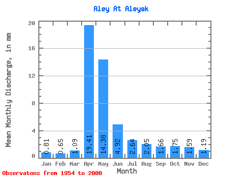
| Statistic | Jan | Feb | Mar | Apr | May | Jun | Jul | Aug | Sep | Oct | Nov | Dec | Annual |
|---|---|---|---|---|---|---|---|---|---|---|---|---|---|
| Mean | 0.81 | 0.66 | 1.09 | 19.41 | 14.37 | 4.92 | 2.64 | 2.05 | 1.66 | 1.75 | 1.59 | 1.19 | 50.80 |
| Standard Deviation | 0.45 | 0.39 | 1.02 | 11.94 | 9.73 | 2.99 | 1.40 | 1.04 | 0.83 | 0.91 | 0.79 | 0.60 | 21.56 |
| Min | 0.02 | 0.01 | 0.01 | 1.68 | 1.99 | 1.06 | 0.81 | 0.58 | 0.57 | 0.68 | 0.49 | 0.14 | 20.48 |
| Max | 1.79 | 1.76 | 5.63 | 54.89 | 44.68 | 13.82 | 5.71 | 5.44 | 4.21 | 4.30 | 3.88 | 2.85 | 111.42 |
| Coefficient of Variation | 0.56 | 0.59 | 0.93 | 0.61 | 0.68 | 0.61 | 0.53 | 0.51 | 0.50 | 0.52 | 0.49 | 0.50 | 0.42 |
 Return to R-Arctic Net Home Page