|
|
|||||||||||||||||
| Point ID: 6724 | Downloads | Plots | Site Data | Code: 10153 |
|
|
|||||||||||||||||
| Download | |
|---|---|
| Site Descriptor Information | Site Time Series Data |
| Link to all available data | |
| View: | Time Series | All |
| Units: | mm |
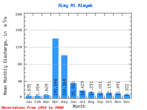
| Statistic | Jan | Feb | Mar | Apr | May | Jun | Jul | Aug | Sep | Oct | Nov | Dec | Annual |
|---|---|---|---|---|---|---|---|---|---|---|---|---|---|
| Mean | 5.63 | 5.05 | 7.61 | 140.05 | 100.37 | 35.50 | 18.43 | 14.29 | 12.00 | 12.19 | 11.49 | 8.32 | 30.10 |
| Standard Deviation | 3.15 | 2.98 | 7.11 | 86.11 | 67.96 | 21.56 | 9.75 | 7.28 | 5.98 | 6.36 | 5.68 | 4.16 | 12.78 |
| Min | 0.12 | 0.07 | 0.07 | 12.10 | 13.90 | 7.67 | 5.69 | 4.04 | 4.10 | 4.74 | 3.56 | 0.96 | 12.13 |
| Max | 12.50 | 13.50 | 39.30 | 396.00 | 312.00 | 99.70 | 39.90 | 38.00 | 30.40 | 30.00 | 28.00 | 19.90 | 66.02 |
| Coefficient of Variation | 0.56 | 0.59 | 0.93 | 0.61 | 0.68 | 0.61 | 0.53 | 0.51 | 0.50 | 0.52 | 0.49 | 0.50 | 0.42 |
 Return to R-Arctic Net Home Page