|
|
|||||||||||||||||
| Point ID: 6716 | Downloads | Plots | Site Data | Code: 10137 |
|
|
|||||||||||||||||
| Download | |
|---|---|
| Site Descriptor Information | Site Time Series Data |
| Link to all available data | |
| View: | Time Series | All |
| Units: | m3/s |
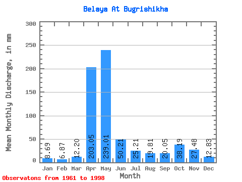
| Statistic | Jan | Feb | Mar | Apr | May | Jun | Jul | Aug | Sep | Oct | Nov | Dec | Annual |
|---|---|---|---|---|---|---|---|---|---|---|---|---|---|
| Mean | 8.69 | 6.93 | 12.20 | 203.05 | 238.98 | 50.21 | 25.21 | 19.81 | 20.05 | 38.18 | 27.48 | 12.83 | 678.94 |
| Standard Deviation | 2.84 | 1.73 | 8.26 | 67.26 | 114.34 | 30.47 | 17.90 | 12.80 | 18.13 | 31.32 | 27.34 | 6.36 | 179.83 |
| Min | 5.00 | 4.32 | 5.10 | 75.94 | 83.63 | 13.89 | 8.10 | 6.41 | 6.78 | 7.82 | 7.57 | 5.38 | 452.61 |
| Max | 17.05 | 10.81 | 46.04 | 452.46 | 526.20 | 144.61 | 83.63 | 58.26 | 98.45 | 171.25 | 165.07 | 35.47 | 1064.50 |
| Coefficient of Variation | 0.33 | 0.25 | 0.68 | 0.33 | 0.48 | 0.61 | 0.71 | 0.65 | 0.90 | 0.82 | 0.99 | 0.50 | 0.27 |
 Return to R-Arctic Net Home Page