|
|
|||||||||||||||||
| Point ID: 6716 | Downloads | Plots | Site Data | Code: 10137 |
|
|
|||||||||||||||||
| Download | |
|---|---|
| Site Descriptor Information | Site Time Series Data |
| Link to all available data | |
|
|
| View: | Statistics | Time Series |
| Units: | m3/s |
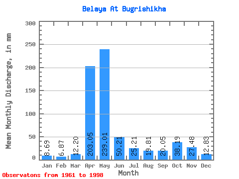
| Statistic | Jan | Feb | Mar | Apr | May | Jun | Jul | Aug | Sep | Oct | Nov | Dec | Annual |
|---|---|---|---|---|---|---|---|---|---|---|---|---|---|
| Mean | 8.69 | 6.93 | 12.20 | 203.05 | 238.98 | 50.21 | 25.21 | 19.81 | 20.05 | 38.18 | 27.48 | 12.83 | 678.94 |
| Standard Deviation | 2.84 | 1.73 | 8.26 | 67.26 | 114.34 | 30.47 | 17.90 | 12.80 | 18.13 | 31.32 | 27.34 | 6.36 | 179.83 |
| Min | 5.00 | 4.32 | 5.10 | 75.94 | 83.63 | 13.89 | 8.10 | 6.41 | 6.78 | 7.82 | 7.57 | 5.38 | 452.61 |
| Max | 17.05 | 10.81 | 46.04 | 452.46 | 526.20 | 144.61 | 83.63 | 58.26 | 98.45 | 171.25 | 165.07 | 35.47 | 1064.50 |
| Coefficient of Variation | 0.33 | 0.25 | 0.68 | 0.33 | 0.48 | 0.61 | 0.71 | 0.65 | 0.90 | 0.82 | 0.99 | 0.50 | 0.27 |
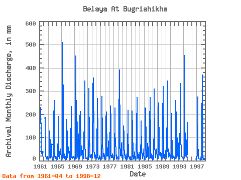
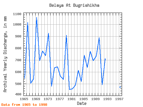
| Year | Jan | Feb | Mar | Apr | May | Jun | Jul | Aug | Sep | Oct | Nov | Dec | Annual | 1961 | 229.64 | 98.19 | 30.47 | 42.28 | 37.35 | 20.35 | 38.99 | 1962 | 189.34 | 24.33 | 9.87 | 7.42 | 6.78 | 18.49 | 8.69 | 8.08 | 1963 | 7.99 | 6.12 | 15.32 | 75.94 | 132.96 | 57.75 | 11.13 | 16.56 | 15.80 | 71.41 | 1964 | 6.32 | 170.75 | 267.80 | 46.38 | 17.17 | 12.57 | 10.53 | 18.56 | 16.42 | 13.27 | 1965 | 7.68 | 5.29 | 9.47 | 135.06 | 196.39 | 22.26 | 9.02 | 30.54 | 30.01 | 51.68 | 33.88 | 18.44 | 547.57 | 1966 | 8.10 | 6.83 | 7.02 | 208.72 | 526.20 | 144.61 | 38.76 | 17.08 | 10.25 | 15.81 | 28.19 | 9.16 | 1015.87 | 1967 | 6.20 | 6.06 | 8.32 | 178.03 | 83.63 | 13.89 | 29.36 | 58.26 | 32.74 | 61.55 | 19.37 | 8.22 | 505.10 | 1968 | 6.11 | 4.32 | 46.04 | 234.19 | 154.81 | 14.57 | 17.03 | 9.07 | 14.14 | 19.50 | 12.94 | 9.37 | 541.78 | 1969 | 6.37 | 5.50 | 7.47 | 221.68 | 465.13 | 69.35 | 14.99 | 9.42 | 17.78 | 171.25 | 63.89 | 13.11 | 1059.50 | 1970 | 10.78 | 7.21 | 11.42 | 176.89 | 218.00 | 57.30 | 21.05 | 25.61 | 63.21 | 47.45 | 43.43 | 13.15 | 694.83 | 1971 | 10.48 | 9.87 | 11.11 | 238.74 | 354.72 | 75.94 | 21.49 | 15.39 | 10.21 | 9.56 | 12.87 | 7.99 | 776.36 | 1972 | 6.22 | 5.52 | 6.06 | 168.48 | 321.83 | 60.94 | 76.35 | 15.76 | 14.64 | 23.14 | 26.60 | 17.29 | 738.87 | 1973 | 12.73 | 10.23 | 14.49 | 311.50 | 368.81 | 67.07 | 47.69 | 24.67 | 10.98 | 25.14 | 20.28 | 14.94 | 926.22 | 1974 | 8.71 | 7.47 | 8.62 | 268.30 | 98.66 | 17.30 | 8.10 | 6.41 | 15.71 | 21.52 | 9.69 | 7.07 | 479.86 | 1975 | 5.71 | 5.01 | 8.69 | 130.28 | 286.59 | 94.36 | 14.07 | 8.95 | 21.99 | 32.89 | 20.37 | 9.33 | 635.98 | 1976 | 6.58 | 5.22 | 6.81 | 175.98 | 215.88 | 21.08 | 41.58 | 21.19 | 26.15 | 87.39 | 25.69 | 13.15 | 643.73 | 1977 | 7.75 | 6.46 | 8.69 | 236.46 | 173.37 | 23.19 | 14.05 | 23.35 | 13.78 | 30.07 | 15.07 | 10.66 | 562.84 | 1978 | 7.02 | 6.04 | 8.27 | 226.91 | 88.09 | 97.77 | 21.14 | 26.07 | 8.39 | 17.50 | 16.26 | 11.56 | 537.40 | 1979 | 10.17 | 7.47 | 7.87 | 137.56 | 404.05 | 91.40 | 83.63 | 23.42 | 20.89 | 78.93 | 34.56 | 16.26 | 909.77 | 1980 | 9.89 | 7.06 | 7.87 | 148.47 | 110.64 | 62.53 | 27.95 | 18.11 | 8.30 | 11.53 | 28.65 | 10.95 | 452.61 | 1981 | 7.56 | 5.71 | 14.68 | 216.68 | 122.86 | 23.42 | 12.12 | 8.24 | 8.32 | 19.59 | 11.51 | 6.51 | 458.04 | 1982 | 5.66 | 4.90 | 5.10 | 213.50 | 136.01 | 22.33 | 9.51 | 8.29 | 7.34 | 38.29 | 24.10 | 11.16 | 486.67 | 1983 | 9.02 | 7.58 | 12.92 | 135.28 | 281.89 | 59.12 | 15.27 | 8.83 | 13.69 | 22.01 | 36.38 | 13.34 | 613.00 | 1984 | 6.76 | 4.58 | 12.83 | 125.05 | 175.95 | 40.02 | 23.49 | 30.07 | 9.78 | 53.33 | 25.69 | 13.51 | 518.69 | 1985 | 8.81 | 6.53 | 6.60 | 227.14 | 232.56 | 66.85 | 20.18 | 14.56 | 18.76 | 76.35 | 44.79 | 18.84 | 740.95 | 1986 | 11.53 | 8.39 | 9.26 | 154.38 | 281.89 | 80.03 | 16.30 | 10.88 | 13.85 | 29.36 | 15.35 | 8.03 | 637.20 | 1987 | 6.58 | 7.17 | 8.93 | 178.71 | 319.48 | 56.84 | 39.23 | 14.80 | 36.61 | 52.62 | 38.65 | 17.69 | 774.19 | 1988 | 16.51 | 10.81 | 10.17 | 214.18 | 256.05 | 37.74 | 30.07 | 28.66 | 19.83 | 36.18 | 26.38 | 11.06 | 695.89 | 1989 | 8.97 | 6.94 | 20.74 | 173.94 | 328.88 | 60.48 | 14.87 | 10.60 | 12.16 | 45.57 | 19.05 | 35.47 | 733.77 | 1990 | 17.05 | 9.03 | 30.07 | 254.65 | 354.72 | 39.79 | 49.33 | 51.21 | 15.96 | 20.23 | 32.97 | 16.63 | 887.72 | 1991 | 12.03 | 10.32 | 11.16 | 203.95 | 158.10 | 19.51 | 11.91 | 10.20 | 14.80 | 20.79 | 10.66 | 8.88 | 492.57 | 1992 | 9.33 | 9.14 | 9.65 | 259.20 | 165.85 | 28.42 | 12.50 | 24.90 | 98.45 | 57.08 | 19.42 | 11.42 | 706.80 | 1993 | 7.94 | 7.28 | 13.39 | 223.50 | 342.97 | 97.54 | 38.99 | 19.29 | 13.94 | 14.61 | 12.30 | 9.02 | 798.44 | 1994 | 7.02 | 6.46 | 12.99 | 452.46 | 221.76 | 25.46 | 21.02 | 47.92 | 51.61 | 17.45 | 165.07 | 31.01 | 1064.50 | 1997 | 8.48 | 6.68 | 29.13 | 275.12 | 88.56 | 14.03 | 10.22 | 8.76 | 7.03 | 7.82 | 7.69 | 5.38 | 471.02 | 1998 | 5.00 | 5.37 | 7.19 | 125.28 | 380.56 | 43.43 | 15.81 | 8.64 | 7.18 | 10.95 | 7.57 | 6.11 | 618.42 |
|---|
 Return to R-Arctic Net Home Page