|
|
|||||||||||||||||
| Point ID: 6697 | Downloads | Plots | Site Data | Code: 10100 |
|
|
|||||||||||||||||
| Download | |
|---|---|
| Site Descriptor Information | Site Time Series Data |
| Link to all available data | |
| View: | Time Series | All |
| Units: | m3/s |
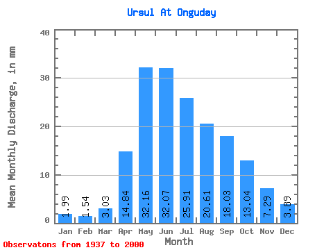
| Statistic | Jan | Feb | Mar | Apr | May | Jun | Jul | Aug | Sep | Oct | Nov | Dec | Annual |
|---|---|---|---|---|---|---|---|---|---|---|---|---|---|
| Mean | 1.99 | 1.55 | 3.03 | 14.84 | 32.16 | 32.07 | 25.91 | 20.61 | 18.03 | 13.04 | 7.29 | 3.88 | 172.16 |
| Standard Deviation | 0.95 | 0.89 | 2.02 | 7.04 | 10.85 | 10.76 | 11.66 | 8.89 | 9.59 | 4.81 | 3.65 | 2.23 | 50.43 |
| Min | 0.49 | 0.35 | 0.50 | 3.53 | 18.00 | 13.30 | 8.78 | 6.72 | 7.50 | 6.74 | 1.35 | 0.68 | 91.14 |
| Max | 4.79 | 4.56 | 8.43 | 40.65 | 70.25 | 61.10 | 73.64 | 47.04 | 68.00 | 29.56 | 20.62 | 11.48 | 315.01 |
| Coefficient of Variation | 0.48 | 0.57 | 0.67 | 0.47 | 0.34 | 0.34 | 0.45 | 0.43 | 0.53 | 0.37 | 0.50 | 0.57 | 0.29 |
 Return to R-Arctic Net Home Page