|
|
|||||||||||||||||
| Point ID: 6697 | Downloads | Plots | Site Data | Code: 10100 |
|
|
|||||||||||||||||
| Download | |
|---|---|
| Site Descriptor Information | Site Time Series Data |
| Link to all available data | |
| View: | Time Series | All |
| Units: | mm |
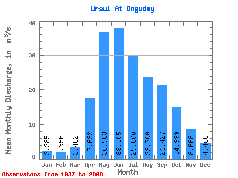
| Statistic | Jan | Feb | Mar | Apr | May | Jun | Jul | Aug | Sep | Oct | Nov | Dec | Annual |
|---|---|---|---|---|---|---|---|---|---|---|---|---|---|
| Mean | 2.29 | 1.96 | 3.48 | 17.63 | 36.98 | 38.10 | 29.80 | 23.70 | 21.43 | 15.00 | 8.67 | 4.47 | 16.80 |
| Standard Deviation | 1.09 | 1.12 | 2.32 | 8.37 | 12.47 | 12.78 | 13.41 | 10.23 | 11.40 | 5.53 | 4.33 | 2.57 | 4.92 |
| Min | 0.56 | 0.44 | 0.57 | 4.19 | 20.70 | 15.80 | 10.10 | 7.73 | 8.91 | 7.75 | 1.60 | 0.78 | 8.89 |
| Max | 5.51 | 5.76 | 9.69 | 48.30 | 80.80 | 72.60 | 84.70 | 54.10 | 80.80 | 34.00 | 24.50 | 13.20 | 30.74 |
| Coefficient of Variation | 0.48 | 0.57 | 0.67 | 0.47 | 0.34 | 0.34 | 0.45 | 0.43 | 0.53 | 0.37 | 0.50 | 0.57 | 0.29 |
 Return to R-Arctic Net Home Page