|
|
|||||||||||||||||
| Point ID: 6690 | Downloads | Plots | Site Data | Code: 10079 |
|
|
|||||||||||||||||
| Download | |
|---|---|
| Site Descriptor Information | Site Time Series Data |
| Link to all available data | |
| View: | Time Series | All |
| Units: | m3/s |
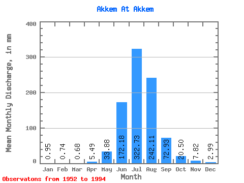
| Statistic | Jan | Feb | Mar | Apr | May | Jun | Jul | Aug | Sep | Oct | Nov | Dec | Annual |
|---|---|---|---|---|---|---|---|---|---|---|---|---|---|
| Mean | 0.97 | 0.73 | 0.67 | 5.47 | 33.86 | 172.17 | 322.69 | 242.08 | 72.93 | 20.51 | 7.82 | 2.98 | 841.68 |
| Standard Deviation | 1.30 | 1.15 | 1.08 | 8.73 | 24.32 | 52.36 | 85.42 | 50.72 | 28.40 | 8.14 | 3.60 | 2.39 | 257.19 |
| Min | 0.00 | 0.00 | 0.00 | 0.00 | 6.11 | 76.87 | 164.28 | 100.13 | 34.82 | 10.52 | 2.07 | 0.17 | 448.53 |
| Max | 4.41 | 3.40 | 3.22 | 39.09 | 90.96 | 250.33 | 536.28 | 319.39 | 130.09 | 43.11 | 15.44 | 8.82 | 1079.40 |
| Coefficient of Variation | 1.34 | 1.57 | 1.61 | 1.59 | 0.72 | 0.30 | 0.27 | 0.21 | 0.39 | 0.40 | 0.46 | 0.80 | 0.31 |
 Return to R-Arctic Net Home Page