|
|
|||||||||||||||||
| Point ID: 6690 | Downloads | Plots | Site Data | Code: 10079 |
|
|
|||||||||||||||||
| Download | |
|---|---|
| Site Descriptor Information | Site Time Series Data |
| Link to all available data | |
|
|
| View: | Statistics | Time Series |
| Units: | m3/s |
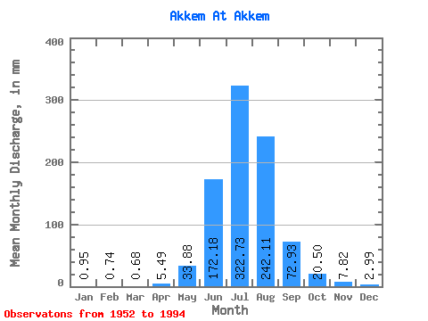
| Statistic | Jan | Feb | Mar | Apr | May | Jun | Jul | Aug | Sep | Oct | Nov | Dec | Annual |
|---|---|---|---|---|---|---|---|---|---|---|---|---|---|
| Mean | 0.97 | 0.73 | 0.67 | 5.47 | 33.86 | 172.17 | 322.69 | 242.08 | 72.93 | 20.51 | 7.82 | 2.98 | 841.68 |
| Standard Deviation | 1.30 | 1.15 | 1.08 | 8.73 | 24.32 | 52.36 | 85.42 | 50.72 | 28.40 | 8.14 | 3.60 | 2.39 | 257.19 |
| Min | 0.00 | 0.00 | 0.00 | 0.00 | 6.11 | 76.87 | 164.28 | 100.13 | 34.82 | 10.52 | 2.07 | 0.17 | 448.53 |
| Max | 4.41 | 3.40 | 3.22 | 39.09 | 90.96 | 250.33 | 536.28 | 319.39 | 130.09 | 43.11 | 15.44 | 8.82 | 1079.40 |
| Coefficient of Variation | 1.34 | 1.57 | 1.61 | 1.59 | 0.72 | 0.30 | 0.27 | 0.21 | 0.39 | 0.40 | 0.46 | 0.80 | 0.31 |
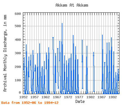
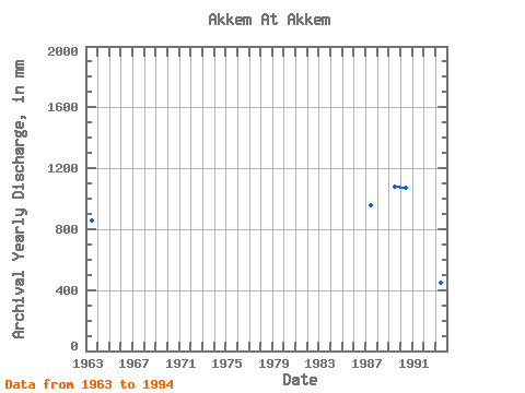
| Year | Jan | Feb | Mar | Apr | May | Jun | Jul | Aug | Sep | Oct | Nov | Dec | Annual | 1952 | 177.07 | 276.62 | 239.97 | 98.88 | 22.74 | 9.20 | 2.14 | 1953 | 0.56 | 55.66 | 214.85 | 373.36 | 267.12 | 128.45 | 34.96 | 13.47 | 8.82 | 1954 | 4.41 | 0.71 | 1.51 | 7.13 | 119.25 | 214.17 | 280.02 | 126.15 | 1955 | 211.56 | 289.18 | 296.99 | 58.15 | 22.40 | 1956 | 3.22 | 39.09 | 90.96 | 129.11 | 330.59 | 261.69 | 69.97 | 24.10 | 14.46 | 7.13 | 1957 | 169.84 | 221.30 | 207.38 | 37.78 | 16.97 | 1958 | 0.07 | 7.23 | 14.60 | 88.70 | 304.80 | 305.48 | 104.80 | 25.46 | 15.44 | 6.79 | 1959 | 6.24 | 32.92 | 203.02 | 380.15 | 234.88 | 95.93 | 15.27 | 7.56 | 3.39 | 1960 | 0.76 | 8.82 | 76.87 | 187.02 | 207.38 | 72.93 | 17.65 | 6.24 | 0.27 | 1961 | 0.07 | 2.59 | 23.76 | 118.59 | 248.45 | 205.35 | 71.29 | 10.52 | 7.88 | 2.44 | 1962 | 187.25 | 312.26 | 279.34 | 82.46 | 13.92 | 5.58 | 0.37 | 1963 | 1.19 | 2.04 | 1.39 | 1.08 | 18.33 | 166.23 | 352.99 | 267.80 | 36.47 | 12.90 | 4.27 | 3.73 | 859.83 | 1965 | 427.67 | 242.68 | 48.95 | 15.61 | 6.90 | 2.21 | 1966 | 2.95 | 2.35 | 2.07 | 1.94 | 6.11 | 115.97 | 306.83 | 268.14 | 85.74 | 1967 | 342.81 | 255.92 | 69.97 | 43.11 | 1968 | 244.09 | 400.51 | 227.75 | 34.82 | 12.22 | 1969 | 3.40 | 0.03 | 2.69 | 48.20 | 250.33 | 536.28 | 212.81 | 87.39 | 22.06 | 9.20 | 4.07 | 1970 | 0.14 | 34.28 | 161.63 | 290.20 | 266.10 | 64.72 | 13.58 | 3.06 | 0.17 | 1971 | 2.68 | 2.37 | 19.69 | 140.28 | 252.53 | 180.23 | 68.00 | 20.36 | 8.54 | 2.31 | 1972 | 19.71 | 17.31 | 206.97 | 251.85 | 269.16 | 46.65 | 11.20 | 3.94 | 1973 | 0.85 | 6.45 | 236.53 | 303.78 | 264.07 | 82.79 | 19.35 | 8.54 | 1.22 | 1974 | 0.03 | 5.91 | 41.07 | 156.70 | 444.64 | 319.39 | 41.39 | 14.93 | 5.91 | 0.81 | 1975 | 1.19 | 0.93 | 0.20 | 16.97 | 149.47 | 359.78 | 232.16 | 53.55 | 15.27 | 6.24 | 1.26 | 1976 | 4.60 | 43.45 | 247.37 | 261.01 | 218.59 | 71.62 | 22.06 | 2.07 | 1978 | 234.89 | 410.69 | 175.48 | 40.74 | 1980 | 2.27 | 86.21 | 194.15 | 363.18 | 264.07 | 128.12 | 41.41 | 14.78 | 7.13 | 1983 | 288.84 | 316.34 | 106.77 | 18.67 | 1987 | 0.00 | 0.00 | 0.00 | 0.00 | 41.41 | 142.91 | 448.03 | 228.43 | 72.93 | 29.87 | 2.69 | 0.44 | 956.50 | 1988 | 0.27 | 0.03 | 0.00 | 1.77 | 15.61 | 176.09 | 236.23 | 27.49 | 9.20 | 2.38 | 1989 | 0.17 | 0.00 | 0.00 | 2.59 | 28.85 | 206.64 | 386.94 | 290.54 | 130.09 | 28.85 | 9.53 | 3.33 | 1079.40 | 1990 | 0.14 | 0.00 | 0.95 | 18.40 | 69.58 | 244.42 | 390.33 | 264.75 | 64.39 | 14.26 | 6.90 | 3.36 | 1069.03 | 1991 | 1.12 | 0.00 | 0.00 | 3.94 | 54.65 | 227.33 | 427.67 | 284.77 | 54.86 | 19.01 | 9.53 | 5.09 | 1078.10 | 1992 | 1.59 | 0.00 | 0.07 | 2.27 | 63.13 | 111.04 | 321.77 | 181.25 | 54.53 | 14.60 | 5.58 | 2.51 | 750.40 | 1993 | 0.34 | 0.00 | 0.00 | 0.53 | 9.84 | 82.46 | 164.28 | 114.72 | 49.61 | 20.03 | 9.53 | 0.68 | 448.53 | 1994 | 0.00 | 0.00 | 0.00 | 2.50 | 25.46 | 117.94 | 187.36 | 100.13 | 38.77 | 15.61 | 4.93 | 2.48 | 491.63 |
|---|
 Return to R-Arctic Net Home Page