|
|
|||||||||||||||||
| Point ID: 6689 | Downloads | Plots | Site Data | Code: 10078 |
|
|
|||||||||||||||||
| Download | |
|---|---|
| Site Descriptor Information | Site Time Series Data |
| Link to all available data | |
| View: | Time Series | All |
| Units: | m3/s |
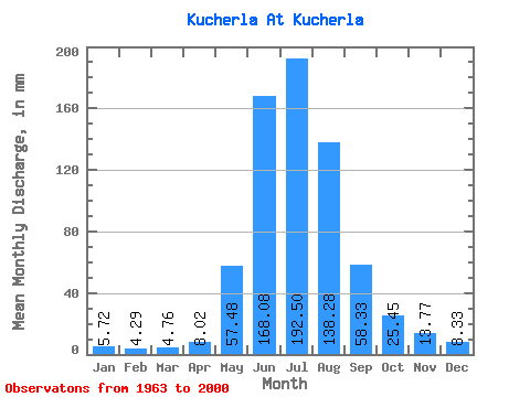
| Statistic | Jan | Feb | Mar | Apr | May | Jun | Jul | Aug | Sep | Oct | Nov | Dec | Annual |
|---|---|---|---|---|---|---|---|---|---|---|---|---|---|
| Mean | 5.72 | 4.33 | 4.76 | 8.03 | 57.47 | 168.08 | 192.47 | 138.25 | 58.33 | 25.45 | 13.77 | 8.33 | 681.28 |
| Standard Deviation | 1.55 | 1.45 | 1.34 | 3.42 | 22.38 | 41.24 | 35.56 | 20.91 | 13.35 | 6.67 | 5.30 | 2.64 | 102.21 |
| Min | 2.86 | 1.44 | 2.78 | 2.98 | 28.83 | 100.45 | 146.93 | 94.39 | 34.68 | 14.31 | 7.36 | 5.21 | 503.69 |
| Max | 8.88 | 8.09 | 8.46 | 18.07 | 107.20 | 258.79 | 312.65 | 179.81 | 100.87 | 42.11 | 34.02 | 18.15 | 923.56 |
| Coefficient of Variation | 0.27 | 0.33 | 0.28 | 0.43 | 0.39 | 0.24 | 0.18 | 0.15 | 0.23 | 0.26 | 0.39 | 0.32 | 0.15 |
 Return to R-Arctic Net Home Page