|
|
|||||||||||||||||
| Point ID: 6689 | Downloads | Plots | Site Data | Code: 10078 |
|
|
|||||||||||||||||
| Download | |
|---|---|
| Site Descriptor Information | Site Time Series Data |
| Link to all available data | |
|
|
| View: | Statistics | Time Series |
| Units: | m3/s |
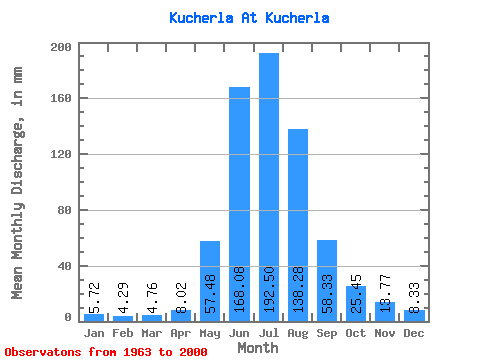
| Statistic | Jan | Feb | Mar | Apr | May | Jun | Jul | Aug | Sep | Oct | Nov | Dec | Annual |
|---|---|---|---|---|---|---|---|---|---|---|---|---|---|
| Mean | 5.72 | 4.33 | 4.76 | 8.03 | 57.47 | 168.08 | 192.47 | 138.25 | 58.33 | 25.45 | 13.77 | 8.33 | 681.28 |
| Standard Deviation | 1.55 | 1.45 | 1.34 | 3.42 | 22.38 | 41.24 | 35.56 | 20.91 | 13.35 | 6.67 | 5.30 | 2.64 | 102.21 |
| Min | 2.86 | 1.44 | 2.78 | 2.98 | 28.83 | 100.45 | 146.93 | 94.39 | 34.68 | 14.31 | 7.36 | 5.21 | 503.69 |
| Max | 8.88 | 8.09 | 8.46 | 18.07 | 107.20 | 258.79 | 312.65 | 179.81 | 100.87 | 42.11 | 34.02 | 18.15 | 923.56 |
| Coefficient of Variation | 0.27 | 0.33 | 0.28 | 0.43 | 0.39 | 0.24 | 0.18 | 0.15 | 0.23 | 0.26 | 0.39 | 0.32 | 0.15 |
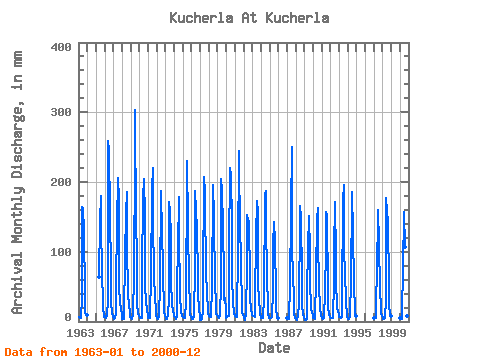
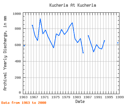
| Year | Jan | Feb | Mar | Apr | May | Jun | Jul | Aug | Sep | Oct | Nov | Dec | Annual | 1963 | 6.32 | 4.51 | 5.00 | 5.29 | 34.55 | 164.53 | 166.57 | 135.82 | 38.32 | 14.31 | 9.76 | 9.53 | 591.39 | 1965 | 65.78 | 143.45 | 185.37 | 140.09 | 73.17 | 24.90 | 21.08 | 6.36 | 1966 | 7.77 | 4.83 | 4.87 | 9.51 | 29.86 | 258.79 | 252.00 | 161.88 | 67.80 | 27.34 | 12.36 | 6.41 | 840.09 | 1967 | 5.12 | 3.35 | 5.12 | 11.20 | 54.67 | 139.73 | 212.70 | 179.81 | 52.09 | 26.48 | 19.35 | 8.93 | 713.25 | 1968 | 3.20 | 3.27 | 3.29 | 7.52 | 98.24 | 154.61 | 191.77 | 115.32 | 37.08 | 25.50 | 12.48 | 6.79 | 654.48 | 1969 | 5.81 | 4.01 | 5.08 | 7.36 | 70.90 | 236.05 | 312.65 | 140.09 | 100.87 | 26.01 | 11.66 | 7.73 | 923.56 | 1970 | 4.61 | 4.75 | 5.25 | 4.79 | 74.32 | 177.35 | 211.42 | 155.04 | 53.33 | 27.51 | 18.15 | 6.28 | 738.20 | 1971 | 5.81 | 4.44 | 4.61 | 14.06 | 62.79 | 189.75 | 226.80 | 148.21 | 68.21 | 32.03 | 20.38 | 9.05 | 782.00 | 1972 | 5.89 | 3.77 | 3.84 | 6.49 | 55.95 | 186.44 | 172.98 | 149.06 | 60.36 | 26.40 | 13.97 | 8.37 | 690.18 | 1973 | 5.34 | 3.81 | 3.89 | 9.92 | 34.21 | 171.97 | 163.58 | 126.00 | 59.12 | 23.36 | 16.54 | 9.99 | 625.24 | 1974 | 7.86 | 5.88 | 3.89 | 7.44 | 54.67 | 105.83 | 184.09 | 134.97 | 34.68 | 15.80 | 7.36 | 7.73 | 565.60 | 1975 | 6.92 | 5.21 | 5.08 | 5.71 | 30.80 | 208.77 | 237.05 | 143.94 | 52.50 | 29.51 | 10.58 | 6.28 | 738.58 | 1976 | 6.88 | 3.77 | 4.10 | 8.23 | 79.44 | 187.68 | 165.29 | 135.82 | 64.08 | 36.01 | 21.04 | 5.21 | 714.21 | 1977 | 2.86 | 1.83 | 4.44 | 14.80 | 55.52 | 207.11 | 192.20 | 176.40 | 71.10 | 42.11 | 14.51 | 12.43 | 791.26 | 1978 | 8.88 | 5.64 | 6.41 | 14.18 | 45.70 | 195.54 | 202.88 | 154.62 | 50.85 | 29.51 | 11.33 | 9.27 | 731.03 | 1979 | 6.19 | 5.25 | 5.04 | 8.31 | 57.66 | 203.81 | 193.48 | 141.80 | 63.66 | 31.39 | 34.02 | 18.15 | 765.59 | 1980 | 5.59 | 5.56 | 7.69 | 8.06 | 107.20 | 220.75 | 214.84 | 146.50 | 66.56 | 23.92 | 14.35 | 12.56 | 829.27 | 1981 | 8.59 | 5.41 | 6.88 | 11.53 | 102.93 | 245.14 | 218.68 | 153.33 | 77.31 | 25.24 | 12.57 | 9.01 | 872.72 | 1982 | 6.24 | 2.49 | 5.12 | 8.06 | 85.00 | 152.96 | 150.77 | 147.35 | 59.12 | 33.70 | 19.26 | 10.21 | 676.12 | 1983 | 8.03 | 8.09 | 8.46 | 6.08 | 29.81 | 123.19 | 178.11 | 161.02 | 55.81 | 29.77 | 15.67 | 10.42 | 630.40 | 1984 | 5.85 | 6.77 | 6.92 | 4.55 | 34.08 | 182.72 | 193.91 | 147.78 | 64.08 | 20.89 | 10.75 | 5.25 | 680.49 | 1985 | 5.34 | 4.20 | 5.00 | 7.07 | 44.85 | 108.72 | 146.93 | 119.17 | 35.26 | 15.38 | 9.84 | 5.38 | 503.69 | 1987 | 5.47 | 2.88 | 3.29 | 5.83 | 51.25 | 157.92 | 258.83 | 111.90 | 62.42 | 39.21 | 10.58 | 5.72 | 710.48 | 1988 | 3.20 | 2.49 | 3.25 | 6.74 | 28.83 | 144.69 | 171.70 | 153.76 | 63.66 | 23.58 | 10.34 | 5.51 | 614.25 | 1989 | 2.99 | 1.44 | 2.78 | 2.98 | 44.42 | 105.00 | 156.75 | 104.22 | 57.46 | 19.35 | 12.44 | 9.48 | 515.93 | 1990 | 5.38 | 4.86 | 4.40 | 4.92 | 65.35 | 146.34 | 167.86 | 119.17 | 53.33 | 17.85 | 9.38 | 7.43 | 602.85 | 1991 | 5.64 | 3.70 | 3.33 | 5.50 | 44.85 | 102.11 | 161.88 | 157.60 | 44.65 | 19.31 | 10.05 | 6.19 | 560.31 | 1992 | 5.17 | 4.36 | 4.66 | 5.25 | 58.52 | 100.45 | 176.82 | 94.39 | 60.36 | 19.77 | 14.84 | 9.70 | 550.66 | 1993 | 7.30 | 6.69 | 5.34 | 6.61 | 33.78 | 172.39 | 201.60 | 103.36 | 72.76 | 28.15 | 10.21 | 6.02 | 651.67 | 1994 | 4.19 | 3.15 | 3.80 | 6.45 | 63.21 | 176.52 | 191.35 | 131.12 | 52.50 | 17.30 | 8.97 | 8.63 | 663.50 | 1997 | 5.25 | 4.83 | 4.70 | 18.07 | 83.29 | 145.93 | 165.72 | 114.89 | 47.13 | 18.92 | 11.33 | 8.97 | 625.45 | 1998 | 4.44 | 3.15 | 3.59 | 5.08 | 31.18 | 176.93 | 163.16 | 146.93 | 52.91 | 23.41 | 11.16 | 7.43 | 626.42 | 2000 | 4.91 | 4.24 | 3.33 | 9.22 | 82.86 | 153.37 | 161.88 | 111.05 | 52.50 | 25.84 | 8.06 | 8.41 | 622.14 |
|---|
 Return to R-Arctic Net Home Page