|
|
|||||||||||||||||
| Point ID: 6687 | Downloads | Plots | Site Data | Code: 10075 |
|
|
|||||||||||||||||
| Download | |
|---|---|
| Site Descriptor Information | Site Time Series Data |
| Link to all available data | |
| View: | Time Series | All |
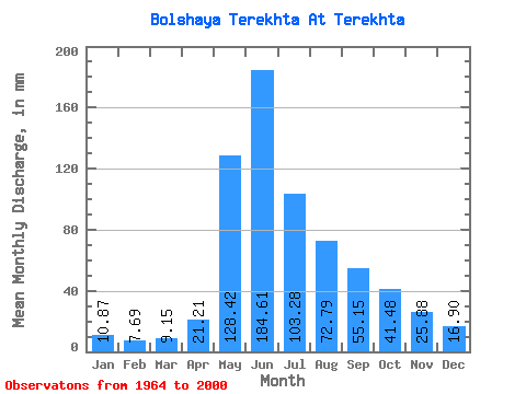
| Units: | m3/s |
| Statistic | Jan | Feb | Mar | Apr | May | Jun | Jul | Aug | Sep | Oct | Nov | Dec | Annual |
|---|---|---|---|---|---|---|---|---|---|---|---|---|---|
| Mean | 10.87 | 7.76 | 9.14 | 21.21 | 128.41 | 184.61 | 103.26 | 72.78 | 55.15 | 41.47 | 25.88 | 16.89 | 675.38 |
| Standard Deviation | 2.77 | 2.04 | 2.49 | 9.50 | 31.88 | 66.69 | 34.81 | 28.75 | 20.09 | 13.27 | 9.13 | 6.01 | 130.28 |
| Min | 6.92 | 5.22 | 4.96 | 10.42 | 68.66 | 76.47 | 45.94 | 33.70 | 30.32 | 18.39 | 9.07 | 8.04 | 399.51 |
| Max | 16.78 | 13.00 | 16.78 | 63.34 | 230.74 | 329.58 | 182.50 | 156.62 | 104.22 | 78.31 | 51.43 | 32.02 | 903.13 |
| Coefficient of Variation | 0.26 | 0.26 | 0.27 | 0.45 | 0.25 | 0.36 | 0.34 | 0.40 | 0.36 | 0.32 | 0.35 | 0.36 | 0.19 |
 Return to R-Arctic Net Home Page