|
|
|||||||||||||||||
| Point ID: 6687 | Downloads | Plots | Site Data | Code: 10075 |
|
|
|||||||||||||||||
| Download | |
|---|---|
| Site Descriptor Information | Site Time Series Data |
| Link to all available data | |
|
|
| View: | Statistics | Time Series |
| Units: | m3/s |
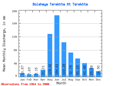
| Statistic | Jan | Feb | Mar | Apr | May | Jun | Jul | Aug | Sep | Oct | Nov | Dec | Annual |
|---|---|---|---|---|---|---|---|---|---|---|---|---|---|
| Mean | 10.87 | 7.76 | 9.14 | 21.21 | 128.41 | 184.61 | 103.26 | 72.78 | 55.15 | 41.47 | 25.88 | 16.89 | 675.38 |
| Standard Deviation | 2.77 | 2.04 | 2.49 | 9.50 | 31.88 | 66.69 | 34.81 | 28.75 | 20.09 | 13.27 | 9.13 | 6.01 | 130.28 |
| Min | 6.92 | 5.22 | 4.96 | 10.42 | 68.66 | 76.47 | 45.94 | 33.70 | 30.32 | 18.39 | 9.07 | 8.04 | 399.51 |
| Max | 16.78 | 13.00 | 16.78 | 63.34 | 230.74 | 329.58 | 182.50 | 156.62 | 104.22 | 78.31 | 51.43 | 32.02 | 903.13 |
| Coefficient of Variation | 0.26 | 0.26 | 0.27 | 0.45 | 0.25 | 0.36 | 0.34 | 0.40 | 0.36 | 0.32 | 0.35 | 0.36 | 0.19 |
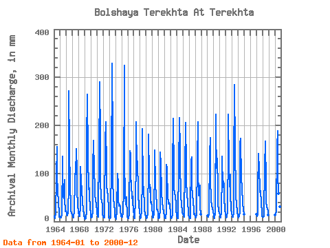
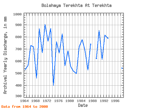
| Year | Jan | Feb | Mar | Apr | May | Jun | Jul | Aug | Sep | Oct | Nov | Dec | Annual | 1964 | 10.91 | 5.73 | 10.28 | 15.09 | 95.79 | 155.66 | 97.19 | 66.08 | 38.17 | 18.39 | 9.07 | 9.02 | 529.50 | 1965 | 8.53 | 7.58 | 9.37 | 11.71 | 139.84 | 105.58 | 54.47 | 49.57 | 87.30 | 48.18 | 20.98 | 23.35 | 564.39 | 1966 | 16.78 | 12.49 | 11.96 | 18.54 | 78.31 | 271.38 | 157.32 | 74.12 | 36.27 | 23.84 | 16.99 | 14.05 | 731.32 | 1967 | 10.70 | 8.22 | 8.25 | 23.28 | 88.10 | 100.16 | 102.09 | 156.62 | 104.22 | 65.73 | 35.80 | 19.86 | 719.44 | 1968 | 12.59 | 10.45 | 11.47 | 30.52 | 117.47 | 83.24 | 65.52 | 43.07 | 36.14 | 30.56 | 11.44 | 8.04 | 458.50 | 1969 | 6.92 | 5.22 | 6.22 | 20.10 | 172.71 | 263.94 | 139.84 | 68.38 | 89.33 | 52.58 | 31.94 | 13.91 | 869.21 | 1970 | 9.72 | 7.64 | 9.02 | 22.33 | 116.77 | 168.51 | 108.38 | 73.42 | 52.92 | 48.46 | 32.48 | 24.33 | 671.65 | 1971 | 16.36 | 9.62 | 9.30 | 24.84 | 141.94 | 289.65 | 182.50 | 86.00 | 51.50 | 41.60 | 35.06 | 16.99 | 903.13 | 1972 | 9.79 | 8.03 | 7.97 | 28.36 | 169.91 | 207.09 | 107.68 | 73.42 | 64.70 | 53.07 | 29.44 | 8.60 | 765.79 | 1973 | 7.34 | 6.12 | 7.69 | 27.61 | 111.88 | 329.58 | 176.20 | 86.70 | 50.01 | 35.17 | 23.28 | 10.07 | 870.65 | 1974 | 7.55 | 5.67 | 4.96 | 24.36 | 102.78 | 76.47 | 45.94 | 33.70 | 35.06 | 29.86 | 22.81 | 11.82 | 399.51 | 1975 | 9.86 | 8.15 | 10.63 | 16.65 | 68.66 | 324.85 | 125.86 | 60.48 | 35.06 | 38.11 | 51.43 | 9.65 | 760.50 | 1976 | 6.92 | 6.12 | 6.50 | 15.09 | 151.73 | 138.74 | 96.49 | 81.11 | 48.46 | 54.54 | 37.70 | 28.81 | 668.56 | 1977 | 7.97 | 5.61 | 16.78 | 36.34 | 132.85 | 207.77 | 113.27 | 130.05 | 63.89 | 59.43 | 31.20 | 23.28 | 825.19 | 1978 | 9.23 | 6.31 | 8.18 | 22.00 | 92.30 | 192.20 | 80.41 | 70.62 | 30.32 | 24.75 | 15.23 | 11.26 | 561.78 | 1979 | 8.39 | 6.50 | 7.83 | 17.93 | 121.66 | 181.37 | 96.49 | 62.86 | 70.38 | 39.99 | 41.49 | 32.02 | 685.38 | 1980 | 12.59 | 7.20 | 7.83 | 16.04 | 120.27 | 148.89 | 83.21 | 52.58 | 39.39 | 26.43 | 25.31 | 17.41 | 555.32 | 1981 | 8.39 | 6.50 | 8.74 | 24.97 | 148.93 | 119.11 | 64.54 | 37.06 | 39.93 | 30.21 | 18.20 | 13.63 | 518.10 | 1982 | 11.26 | 6.56 | 6.36 | 22.20 | 122.36 | 109.64 | 49.51 | 43.35 | 36.61 | 41.04 | 33.43 | 16.71 | 497.30 | 1983 | 9.30 | 5.73 | 8.88 | 14.28 | 111.88 | 213.86 | 107.68 | 74.82 | 56.58 | 55.94 | 35.73 | 26.15 | 718.89 | 1984 | 12.17 | 6.18 | 6.99 | 10.42 | 116.77 | 215.21 | 155.23 | 129.35 | 50.89 | 37.13 | 21.45 | 19.86 | 777.94 | 1985 | 16.15 | 11.40 | 9.58 | 11.71 | 109.78 | 205.74 | 117.47 | 84.61 | 56.31 | 40.55 | 19.69 | 12.87 | 694.03 | 1986 | 9.72 | 5.86 | 6.22 | 14.48 | 130.75 | 134.00 | 69.92 | 61.04 | 37.56 | 29.58 | 14.41 | 16.50 | 527.65 | 1987 | 9.51 | 7.52 | 8.25 | 15.70 | 131.45 | 207.77 | 109.78 | 56.15 | 71.74 | 78.31 | 30.05 | 16.08 | 740.31 | 1989 | 13.01 | 8.92 | 9.86 | 17.12 | 146.14 | 174.60 | 91.60 | 46.71 | 32.89 | 35.38 | 25.65 | 23.77 | 623.44 | 1990 | 10.70 | 6.12 | 6.43 | 18.48 | 230.74 | 187.46 | 115.37 | 135.65 | 69.71 | 39.09 | 22.00 | 16.43 | 853.07 | 1991 | 13.71 | 8.54 | 7.69 | 21.05 | 102.78 | 135.35 | 73.42 | 86.00 | 75.80 | 53.84 | 21.93 | 17.97 | 616.09 | 1992 | 8.60 | 7.39 | 9.02 | 21.25 | 158.02 | 223.33 | 117.47 | 74.82 | 98.13 | 56.71 | 26.60 | 16.22 | 815.64 | 1993 | 12.52 | 8.86 | 10.28 | 19.49 | 114.67 | 284.92 | 155.23 | 64.40 | 50.55 | 39.02 | 17.80 | 14.40 | 790.92 | 1994 | 12.52 | 7.13 | 10.63 | 19.76 | 167.11 | 173.25 | 89.50 | 74.82 | 69.03 | 38.95 | 25.31 | 15.17 | 700.62 | 1997 | 15.03 | 10.64 | 13.84 | 63.34 | 145.44 | 106.93 | 73.42 | 62.72 | 64.09 | 38.67 | 19.22 | 11.82 | 623.23 | 1998 | 9.65 | 9.11 | 10.98 | 12.93 | 118.17 | 167.16 | 81.11 | 41.81 | 30.45 | 26.71 | 20.78 | 14.12 | 541.66 | 2000 | 14.19 | 13.00 | 13.71 | 21.86 | 159.42 | 188.82 | 103.48 | 59.64 | 46.63 | 36.64 | 30.18 | 23.28 | 708.73 |
|---|
 Return to R-Arctic Net Home Page