|
|
|||||||||||||||||
| Point ID: 6685 | Downloads | Plots | Site Data | Code: 10073 |
|
|
|||||||||||||||||
| Download | |
|---|---|
| Site Descriptor Information | Site Time Series Data |
| Link to all available data | |
| View: | Time Series | All |
| Units: | m3/s |
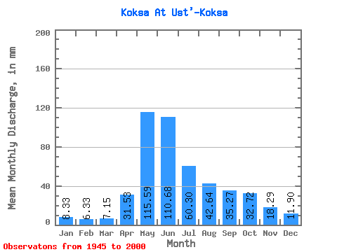
| Statistic | Jan | Feb | Mar | Apr | May | Jun | Jul | Aug | Sep | Oct | Nov | Dec | Annual |
|---|---|---|---|---|---|---|---|---|---|---|---|---|---|
| Mean | 8.33 | 6.39 | 7.15 | 31.53 | 115.57 | 110.67 | 60.29 | 42.63 | 35.27 | 32.72 | 18.29 | 11.89 | 476.02 |
| Standard Deviation | 2.94 | 3.08 | 4.25 | 15.17 | 31.11 | 42.50 | 25.14 | 18.16 | 14.93 | 12.89 | 5.30 | 4.25 | 109.19 |
| Min | 2.35 | 1.50 | 1.91 | 7.87 | 37.35 | 35.04 | 18.32 | 14.01 | 10.69 | 13.53 | 7.82 | 2.11 | 249.50 |
| Max | 16.07 | 17.04 | 25.44 | 68.04 | 190.81 | 190.23 | 153.03 | 89.43 | 96.27 | 87.03 | 32.31 | 24.77 | 718.85 |
| Coefficient of Variation | 0.35 | 0.48 | 0.59 | 0.48 | 0.27 | 0.38 | 0.42 | 0.43 | 0.42 | 0.39 | 0.29 | 0.36 | 0.23 |
 Return to R-Arctic Net Home Page