|
|
|||||||||||||||||
| Point ID: 6685 | Downloads | Plots | Site Data | Code: 10073 |
|
|
|||||||||||||||||
| Download | |
|---|---|
| Site Descriptor Information | Site Time Series Data |
| Link to all available data | |
| View: | Time Series | All |
| Units: | mm |
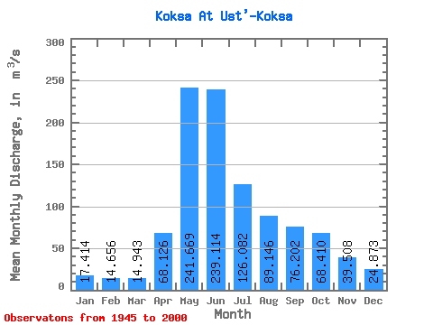
| Statistic | Jan | Feb | Mar | Apr | May | Jun | Jul | Aug | Sep | Oct | Nov | Dec | Annual |
|---|---|---|---|---|---|---|---|---|---|---|---|---|---|
| Mean | 17.41 | 14.66 | 14.94 | 68.13 | 241.67 | 239.11 | 126.08 | 89.15 | 76.20 | 68.41 | 39.51 | 24.87 | 84.47 |
| Standard Deviation | 6.16 | 7.08 | 8.88 | 32.77 | 65.06 | 91.81 | 52.57 | 37.98 | 32.25 | 26.96 | 11.46 | 8.89 | 19.38 |
| Min | 4.92 | 3.43 | 3.99 | 17.00 | 78.10 | 75.70 | 38.30 | 29.30 | 23.10 | 28.30 | 16.90 | 4.42 | 44.27 |
| Max | 33.60 | 39.10 | 53.20 | 147.00 | 399.00 | 411.00 | 320.00 | 187.00 | 208.00 | 182.00 | 69.80 | 51.80 | 127.55 |
| Coefficient of Variation | 0.35 | 0.48 | 0.59 | 0.48 | 0.27 | 0.38 | 0.42 | 0.43 | 0.42 | 0.39 | 0.29 | 0.36 | 0.23 |
 Return to R-Arctic Net Home Page