|
|
|||||||||||||||||
| Point ID: 6674 | Downloads | Plots | Site Data | Code: 10056 |
|
|
|||||||||||||||||
| Download | |
|---|---|
| Site Descriptor Information | Site Time Series Data |
| Link to all available data | |
| View: | Time Series | All |
| Units: | m3/s |
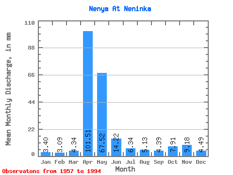
| Statistic | Jan | Feb | Mar | Apr | May | Jun | Jul | Aug | Sep | Oct | Nov | Dec | Annual |
|---|---|---|---|---|---|---|---|---|---|---|---|---|---|
| Mean | 3.40 | 3.11 | 4.34 | 101.51 | 67.51 | 14.22 | 6.34 | 5.13 | 4.39 | 7.91 | 9.18 | 4.49 | 232.28 |
| Standard Deviation | 1.26 | 1.06 | 2.93 | 39.32 | 51.24 | 12.59 | 4.84 | 5.31 | 2.55 | 4.52 | 10.43 | 3.01 | 66.42 |
| Min | 1.01 | 0.78 | 1.08 | 38.25 | 15.60 | 3.01 | 1.70 | 1.87 | 1.79 | 1.70 | 2.23 | 1.85 | 132.92 |
| Max | 6.03 | 5.18 | 18.20 | 215.16 | 253.50 | 66.69 | 23.92 | 33.41 | 13.97 | 20.02 | 50.20 | 17.68 | 375.21 |
| Coefficient of Variation | 0.37 | 0.34 | 0.68 | 0.39 | 0.76 | 0.89 | 0.76 | 1.03 | 0.58 | 0.57 | 1.14 | 0.67 | 0.29 |
 Return to R-Arctic Net Home Page