|
|
|||||||||||||||||
| Point ID: 6674 | Downloads | Plots | Site Data | Code: 10056 |
|
|
|||||||||||||||||
| Download | |
|---|---|
| Site Descriptor Information | Site Time Series Data |
| Link to all available data | |
| View: | Time Series | All |
| Units: | mm |
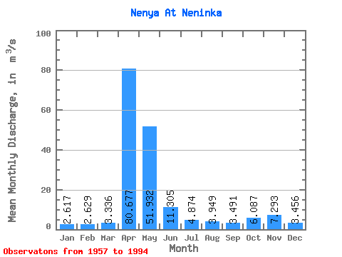
| Statistic | Jan | Feb | Mar | Apr | May | Jun | Jul | Aug | Sep | Oct | Nov | Dec | Annual |
|---|---|---|---|---|---|---|---|---|---|---|---|---|---|
| Mean | 2.62 | 2.63 | 3.34 | 80.68 | 51.93 | 11.30 | 4.87 | 3.95 | 3.49 | 6.09 | 7.29 | 3.46 | 15.16 |
| Standard Deviation | 0.97 | 0.90 | 2.25 | 31.25 | 39.41 | 10.01 | 3.73 | 4.08 | 2.03 | 3.48 | 8.29 | 2.31 | 4.33 |
| Min | 0.78 | 0.66 | 0.83 | 30.40 | 12.00 | 2.39 | 1.31 | 1.44 | 1.42 | 1.31 | 1.77 | 1.42 | 8.68 |
| Max | 4.64 | 4.37 | 14.00 | 171.00 | 195.00 | 53.00 | 18.40 | 25.70 | 11.10 | 15.40 | 39.90 | 13.60 | 24.49 |
| Coefficient of Variation | 0.37 | 0.34 | 0.68 | 0.39 | 0.76 | 0.89 | 0.76 | 1.03 | 0.58 | 0.57 | 1.14 | 0.67 | 0.29 |
 Return to R-Arctic Net Home Page