|
|
|||||||||||||||||
| Point ID: 6672 | Downloads | Plots | Site Data | Code: 10054 |
|
|
|||||||||||||||||
| Download | |
|---|---|
| Site Descriptor Information | Site Time Series Data |
| Link to all available data | |
| View: | Time Series | All |
| Units: | m3/s |
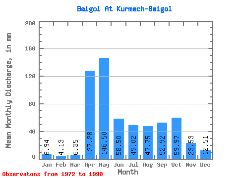
| Statistic | Jan | Feb | Mar | Apr | May | Jun | Jul | Aug | Sep | Oct | Nov | Dec | Annual |
|---|---|---|---|---|---|---|---|---|---|---|---|---|---|
| Mean | 6.94 | 4.16 | 6.36 | 127.28 | 146.47 | 58.50 | 49.01 | 47.74 | 52.92 | 59.96 | 23.53 | 12.51 | 590.91 |
| Standard Deviation | 3.41 | 1.88 | 5.26 | 54.59 | 58.25 | 34.15 | 35.83 | 30.34 | 28.12 | 35.65 | 10.35 | 5.85 | 102.83 |
| Min | 2.84 | 0.75 | 2.06 | 43.07 | 44.63 | 10.99 | 11.54 | 7.64 | 17.68 | 20.46 | 8.86 | 4.99 | 405.25 |
| Max | 13.82 | 8.38 | 22.07 | 230.40 | 259.10 | 140.90 | 149.69 | 124.06 | 120.07 | 155.19 | 52.28 | 26.73 | 745.03 |
| Coefficient of Variation | 0.49 | 0.45 | 0.83 | 0.43 | 0.40 | 0.58 | 0.73 | 0.64 | 0.53 | 0.59 | 0.44 | 0.47 | 0.17 |
 Return to R-Arctic Net Home Page