|
|
|||||||||||||||||
| Point ID: 6672 | Downloads | Plots | Site Data | Code: 10054 |
|
|
|||||||||||||||||
| Download | |
|---|---|
| Site Descriptor Information | Site Time Series Data |
| Link to all available data | |
|
|
| View: | Statistics | Time Series |
| Units: | m3/s |
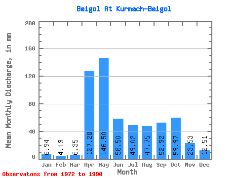
| Statistic | Jan | Feb | Mar | Apr | May | Jun | Jul | Aug | Sep | Oct | Nov | Dec | Annual |
|---|---|---|---|---|---|---|---|---|---|---|---|---|---|
| Mean | 6.94 | 4.16 | 6.36 | 127.28 | 146.47 | 58.50 | 49.01 | 47.74 | 52.92 | 59.96 | 23.53 | 12.51 | 590.91 |
| Standard Deviation | 3.41 | 1.88 | 5.26 | 54.59 | 58.25 | 34.15 | 35.83 | 30.34 | 28.12 | 35.65 | 10.35 | 5.85 | 102.83 |
| Min | 2.84 | 0.75 | 2.06 | 43.07 | 44.63 | 10.99 | 11.54 | 7.64 | 17.68 | 20.46 | 8.86 | 4.99 | 405.25 |
| Max | 13.82 | 8.38 | 22.07 | 230.40 | 259.10 | 140.90 | 149.69 | 124.06 | 120.07 | 155.19 | 52.28 | 26.73 | 745.03 |
| Coefficient of Variation | 0.49 | 0.45 | 0.83 | 0.43 | 0.40 | 0.58 | 0.73 | 0.64 | 0.53 | 0.59 | 0.44 | 0.47 | 0.17 |
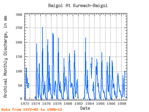
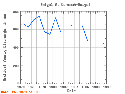
| Year | Jan | Feb | Mar | Apr | May | Jun | Jul | Aug | Sep | Oct | Nov | Dec | Annual | 1972 | 2.84 | 11.81 | 111.66 | 115.36 | 56.71 | 78.28 | 44.59 | 41.69 | 58.14 | 1974 | 11.08 | 6.59 | 2.88 | 194.07 | 84.23 | 58.04 | 11.77 | 7.64 | 120.07 | 130.92 | 20.56 | 13.28 | 662.72 | 1975 | 8.42 | 3.13 | 2.20 | 83.30 | 259.10 | 105.45 | 18.13 | 18.04 | 41.43 | 66.38 | 13.73 | 7.83 | 624.14 | 1976 | 2.84 | 2.84 | 3.98 | 168.81 | 216.53 | 28.80 | 31.04 | 124.06 | 33.50 | 58.60 | 22.24 | 19.46 | 708.44 | 1977 | 13.82 | 4.42 | 4.35 | 230.40 | 230.72 | 38.68 | 17.76 | 40.33 | 66.46 | 65.92 | 26.36 | 6.96 | 745.03 | 1978 | 4.81 | 3.67 | 4.71 | 214.45 | 119.48 | 30.48 | 36.21 | 65.92 | 24.99 | 38.59 | 20.56 | 10.30 | 573.70 | 1979 | 5.31 | 4.17 | 4.17 | 43.07 | 147.86 | 29.33 | 42.02 | 66.38 | 81.08 | 65.92 | 37.84 | 19.87 | 543.85 | 1980 | 4.71 | 3.17 | 3.34 | 124.50 | 165.72 | 111.66 | 81.94 | 44.68 | 49.18 | 60.43 | 52.28 | 26.73 | 726.60 | 1981 | 7.55 | 5.59 | 5.54 | 171.91 | 151.07 | 10.99 | 29.62 | 24.67 | 58.04 | 73.70 | 26.23 | 9.52 | 573.38 | 1983 | 5.40 | 5.76 | 10.30 | 115.20 | 221.11 | 52.73 | 52.19 | 22.29 | 103.68 | 31.31 | 18.25 | 8.65 | 645.27 | 1984 | 3.52 | 0.75 | 2.11 | 128.18 | 75.77 | 149.69 | 33.76 | 64.55 | 31.68 | 4.99 | 1985 | 3.07 | 2.46 | 4.58 | 115.64 | 91.10 | 140.90 | 98.42 | 48.52 | 58.04 | 33.65 | 24.55 | 13.64 | 634.48 | 1986 | 5.77 | 4.63 | 6.68 | 94.82 | 169.84 | 48.30 | 37.67 | 35.16 | 25.74 | 31.72 | 15.02 | 8.06 | 481.18 | 1987 | 4.71 | 3.00 | 3.89 | 70.45 | 135.50 | 74.44 | 33.88 | 28.43 | 65.58 | 155.19 | 20.16 | 12.09 | 604.23 | 1988 | 7.51 | 3.00 | 2.06 | 136.47 | 113.53 | 41.60 | 53.56 | 58.14 | 17.68 | 30.08 | 16.79 | 11.95 | 490.75 | 1989 | 9.61 | 6.34 | 13.37 | 75.77 | 96.13 | 58.49 | 49.44 | 34.74 | 28.67 | 33.83 | 21.36 | 18.22 | 444.58 | 1990 | 12.91 | 8.38 | 22.07 | 85.96 | 44.63 | 32.21 | 11.54 | 100.25 | 50.07 | 20.46 | 8.86 | 8.61 | 405.25 |
|---|
 Return to R-Arctic Net Home Page