|
|
|||||||||||||||||
| Point ID: 6671 | Downloads | Plots | Site Data | Code: 10053 |
|
|
|||||||||||||||||
| Download | |
|---|---|
| Site Descriptor Information | Site Time Series Data |
| Link to all available data | |
| View: | Time Series | All |
| Units: | m3/s |
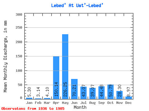
| Statistic | Jan | Feb | Mar | Apr | May | Jun | Jul | Aug | Sep | Oct | Nov | Dec | Annual |
|---|---|---|---|---|---|---|---|---|---|---|---|---|---|
| Mean | 5.29 | 3.17 | 4.10 | 150.14 | 226.21 | 70.21 | 43.06 | 39.07 | 44.48 | 50.78 | 28.30 | 8.97 | 673.25 |
| Standard Deviation | 2.06 | 1.18 | 2.19 | 62.95 | 106.09 | 46.35 | 32.22 | 26.64 | 30.08 | 29.28 | 19.79 | 4.41 | 157.18 |
| Min | 2.24 | 1.17 | 1.40 | 32.31 | 89.86 | 13.88 | 9.46 | 5.95 | 7.32 | 10.24 | 8.12 | 2.36 | 394.34 |
| Max | 15.06 | 6.83 | 11.25 | 282.82 | 526.67 | 236.16 | 145.21 | 135.69 | 129.60 | 130.92 | 111.74 | 21.72 | 1037.13 |
| Coefficient of Variation | 0.39 | 0.37 | 0.53 | 0.42 | 0.47 | 0.66 | 0.75 | 0.68 | 0.68 | 0.58 | 0.70 | 0.49 | 0.23 |
 Return to R-Arctic Net Home Page