|
|
|||||||||||||||||
| Point ID: 6671 | Downloads | Plots | Site Data | Code: 10053 |
|
|
|||||||||||||||||
| Download | |
|---|---|
| Site Descriptor Information | Site Time Series Data |
| Link to all available data | |
| View: | Time Series | All |
| Units: | mm |
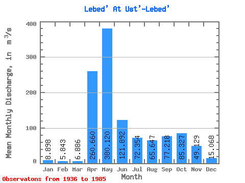
| Statistic | Jan | Feb | Mar | Apr | May | Jun | Jul | Aug | Sep | Oct | Nov | Dec | Annual |
|---|---|---|---|---|---|---|---|---|---|---|---|---|---|
| Mean | 8.90 | 5.84 | 6.89 | 260.66 | 380.12 | 121.89 | 72.35 | 65.65 | 77.22 | 85.33 | 49.13 | 15.07 | 96.00 |
| Standard Deviation | 3.47 | 2.17 | 3.67 | 109.28 | 178.28 | 80.47 | 54.15 | 44.76 | 52.22 | 49.20 | 34.35 | 7.41 | 22.41 |
| Min | 3.77 | 2.16 | 2.35 | 56.10 | 151.00 | 24.10 | 15.90 | 9.99 | 12.70 | 17.20 | 14.10 | 3.96 | 56.23 |
| Max | 25.30 | 12.60 | 18.90 | 491.00 | 885.00 | 410.00 | 244.00 | 228.00 | 225.00 | 220.00 | 194.00 | 36.50 | 147.88 |
| Coefficient of Variation | 0.39 | 0.37 | 0.53 | 0.42 | 0.47 | 0.66 | 0.75 | 0.68 | 0.68 | 0.58 | 0.70 | 0.49 | 0.23 |
 Return to R-Arctic Net Home Page