|
|
|||||||||||||||||
| Point ID: 6630 | Downloads | Plots | Site Data | Code: 9420 |
|
|
|||||||||||||||||
| Download | |
|---|---|
| Site Descriptor Information | Site Time Series Data |
| Link to all available data | |
| View: | Time Series | All |
| Units: | m3/s |
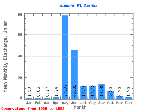
| Statistic | Jan | Feb | Mar | Apr | May | Jun | Jul | Aug | Sep | Oct | Nov | Dec | Annual |
|---|---|---|---|---|---|---|---|---|---|---|---|---|---|
| Mean | 1.30 | 0.86 | 0.77 | 1.74 | 77.96 | 45.32 | 12.10 | 12.12 | 13.93 | 7.30 | 2.90 | 1.90 | 177.16 |
| Standard Deviation | 0.66 | 0.45 | 0.43 | 3.50 | 21.19 | 25.50 | 8.60 | 14.71 | 10.02 | 5.86 | 1.65 | 0.97 | 58.20 |
| Min | 0.23 | 0.08 | 0.07 | 0.07 | 37.82 | 13.01 | 4.04 | 3.49 | 3.15 | 0.97 | 0.66 | 0.36 | 96.46 |
| Max | 2.90 | 1.71 | 1.64 | 19.96 | 129.92 | 115.24 | 31.48 | 81.25 | 37.30 | 26.78 | 6.45 | 4.36 | 321.36 |
| Coefficient of Variation | 0.51 | 0.53 | 0.56 | 2.02 | 0.27 | 0.56 | 0.71 | 1.21 | 0.72 | 0.80 | 0.57 | 0.51 | 0.33 |
 Return to R-Arctic Net Home Page