|
|
|||||||||||||||||
| Point ID: 6630 | Downloads | Plots | Site Data | Code: 9420 |
|
|
|||||||||||||||||
| Download | |
|---|---|
| Site Descriptor Information | Site Time Series Data |
| Link to all available data | |
| View: | Time Series | All |
| Units: | mm |
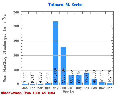
| Statistic | Jan | Feb | Mar | Apr | May | Jun | Jul | Aug | Sep | Oct | Nov | Dec | Annual |
|---|---|---|---|---|---|---|---|---|---|---|---|---|---|
| Mean | 7.21 | 5.21 | 4.23 | 9.93 | 430.84 | 258.79 | 66.86 | 66.98 | 79.52 | 40.33 | 16.58 | 10.47 | 83.08 |
| Standard Deviation | 3.65 | 2.76 | 2.37 | 20.00 | 117.08 | 145.57 | 47.55 | 81.32 | 57.22 | 32.36 | 9.39 | 5.37 | 27.29 |
| Min | 1.26 | 0.47 | 0.41 | 0.42 | 209.00 | 74.30 | 22.30 | 19.30 | 18.00 | 5.34 | 3.79 | 1.98 | 45.24 |
| Max | 16.00 | 10.40 | 9.08 | 114.00 | 718.00 | 658.00 | 174.00 | 449.00 | 213.00 | 148.00 | 36.80 | 24.10 | 150.70 |
| Coefficient of Variation | 0.51 | 0.53 | 0.56 | 2.02 | 0.27 | 0.56 | 0.71 | 1.21 | 0.72 | 0.80 | 0.57 | 0.51 | 0.33 |
 Return to R-Arctic Net Home Page