|
|
|||||||||||||||||
| Point ID: 6625 | Downloads | Plots | Site Data | Code: 9410 |
|
|
|||||||||||||||||
| Download | |
|---|---|
| Site Descriptor Information | Site Time Series Data |
| Link to all available data | |
| View: | Time Series | All |
| Units: | m3/s |
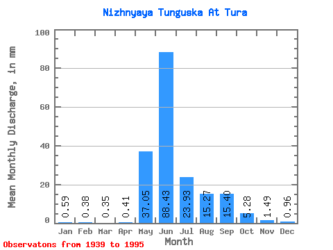
| Statistic | Jan | Feb | Mar | Apr | May | Jun | Jul | Aug | Sep | Oct | Nov | Dec | Annual |
|---|---|---|---|---|---|---|---|---|---|---|---|---|---|
| Mean | 0.59 | 0.39 | 0.35 | 0.41 | 37.04 | 88.43 | 23.93 | 15.27 | 15.40 | 5.27 | 1.49 | 0.96 | 190.52 |
| Standard Deviation | 0.23 | 0.16 | 0.15 | 0.50 | 16.61 | 27.30 | 10.32 | 7.73 | 7.37 | 3.06 | 0.66 | 0.43 | 34.18 |
| Min | 0.21 | 0.13 | 0.11 | 0.10 | 8.68 | 37.14 | 8.01 | 2.86 | 2.13 | 1.23 | 0.21 | 0.13 | 137.78 |
| Max | 1.23 | 0.74 | 0.76 | 3.69 | 74.84 | 147.98 | 56.46 | 42.77 | 40.23 | 12.29 | 3.08 | 2.21 | 271.68 |
| Coefficient of Variation | 0.39 | 0.42 | 0.45 | 1.23 | 0.45 | 0.31 | 0.43 | 0.51 | 0.48 | 0.58 | 0.45 | 0.45 | 0.18 |
 Return to R-Arctic Net Home Page