|
|
|||||||||||||||||
| Point ID: 6625 | Downloads | Plots | Site Data | Code: 9410 |
|
|
|||||||||||||||||
| Download | |
|---|---|
| Site Descriptor Information | Site Time Series Data |
| Link to all available data | |
| View: | Time Series | All |
| Units: | mm |
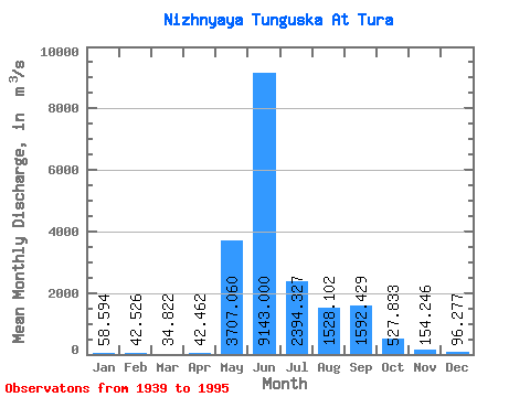
| Statistic | Jan | Feb | Mar | Apr | May | Jun | Jul | Aug | Sep | Oct | Nov | Dec | Annual |
|---|---|---|---|---|---|---|---|---|---|---|---|---|---|
| Mean | 58.59 | 42.53 | 34.82 | 42.46 | 3707.06 | 9143.00 | 2394.33 | 1528.10 | 1592.43 | 527.83 | 154.25 | 96.28 | 1617.82 |
| Standard Deviation | 22.92 | 17.76 | 15.49 | 52.03 | 1661.81 | 2822.15 | 1033.07 | 773.76 | 762.07 | 306.76 | 68.63 | 43.35 | 290.24 |
| Min | 21.10 | 14.50 | 11.10 | 9.98 | 869.00 | 3840.00 | 802.00 | 286.00 | 220.00 | 123.00 | 21.50 | 13.30 | 1169.97 |
| Max | 123.00 | 81.00 | 76.10 | 382.00 | 7490.00 | 15300.00 | 5650.00 | 4280.00 | 4160.00 | 1230.00 | 318.00 | 221.00 | 2307.07 |
| Coefficient of Variation | 0.39 | 0.42 | 0.45 | 1.23 | 0.45 | 0.31 | 0.43 | 0.51 | 0.48 | 0.58 | 0.45 | 0.45 | 0.18 |
 Return to R-Arctic Net Home Page