|
|
|||||||||||||||||
| Point ID: 6616 | Downloads | Plots | Site Data | Code: 9392 |
|
|
|||||||||||||||||
| Download | |
|---|---|
| Site Descriptor Information | Site Time Series Data |
| Link to all available data | |
| View: | Time Series | All |
| Units: | m3/s |
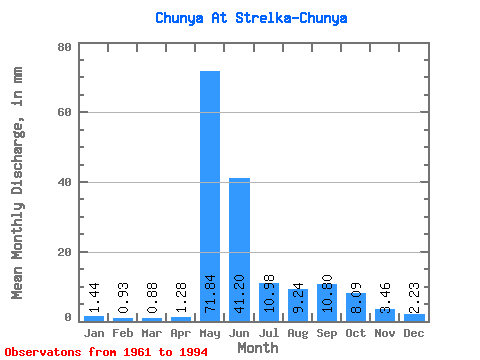
| Statistic | Jan | Feb | Mar | Apr | May | Jun | Jul | Aug | Sep | Oct | Nov | Dec | Annual |
|---|---|---|---|---|---|---|---|---|---|---|---|---|---|
| Mean | 1.44 | 0.94 | 0.88 | 1.28 | 71.83 | 41.20 | 10.98 | 9.24 | 10.79 | 8.09 | 3.46 | 2.23 | 157.10 |
| Standard Deviation | 0.84 | 0.56 | 0.59 | 1.85 | 23.44 | 29.54 | 7.18 | 8.80 | 8.59 | 7.23 | 2.53 | 1.50 | 54.87 |
| Min | 0.49 | 0.18 | 0.18 | 0.24 | 39.67 | 10.10 | 1.89 | 2.50 | 2.69 | 2.00 | 1.13 | 0.79 | 90.32 |
| Max | 3.97 | 2.99 | 3.34 | 10.00 | 124.64 | 130.77 | 31.41 | 40.07 | 39.56 | 33.83 | 11.26 | 7.17 | 275.10 |
| Coefficient of Variation | 0.59 | 0.59 | 0.67 | 1.44 | 0.33 | 0.72 | 0.65 | 0.95 | 0.80 | 0.89 | 0.73 | 0.68 | 0.35 |
 Return to R-Arctic Net Home Page