|
|
|||||||||||||||||
| Point ID: 6616 | Downloads | Plots | Site Data | Code: 9392 |
|
|
|||||||||||||||||
| Download | |
|---|---|
| Site Descriptor Information | Site Time Series Data |
| Link to all available data | |
| View: | Time Series | All |
| Units: | mm |
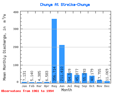
| Statistic | Jan | Feb | Mar | Apr | May | Jun | Jul | Aug | Sep | Oct | Nov | Dec | Annual |
|---|---|---|---|---|---|---|---|---|---|---|---|---|---|
| Mean | 7.13 | 5.14 | 4.38 | 6.58 | 356.71 | 211.41 | 54.51 | 45.88 | 55.39 | 40.18 | 17.75 | 11.07 | 66.21 |
| Standard Deviation | 4.20 | 3.04 | 2.92 | 9.50 | 116.43 | 151.56 | 35.66 | 43.70 | 44.05 | 35.90 | 12.97 | 7.47 | 23.12 |
| Min | 2.45 | 0.99 | 0.91 | 1.23 | 197.00 | 51.80 | 9.38 | 12.40 | 13.80 | 9.92 | 5.78 | 3.90 | 38.06 |
| Max | 19.70 | 16.30 | 16.60 | 51.30 | 619.00 | 671.00 | 156.00 | 199.00 | 203.00 | 168.00 | 57.80 | 35.60 | 115.93 |
| Coefficient of Variation | 0.59 | 0.59 | 0.67 | 1.44 | 0.33 | 0.72 | 0.65 | 0.95 | 0.80 | 0.89 | 0.73 | 0.68 | 0.35 |
 Return to R-Arctic Net Home Page