|
|
|||||||||||||||||
| Point ID: 6611 | Downloads | Plots | Site Data | Code: 9385 |
|
|
|||||||||||||||||
| Download | |
|---|---|
| Site Descriptor Information | Site Time Series Data |
| Link to all available data | |
| View: | Time Series | All |
| Units: | m3/s |
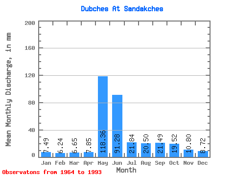
| Statistic | Jan | Feb | Mar | Apr | May | Jun | Jul | Aug | Sep | Oct | Nov | Dec | Annual |
|---|---|---|---|---|---|---|---|---|---|---|---|---|---|
| Mean | 7.49 | 6.29 | 6.64 | 7.86 | 118.34 | 91.28 | 21.83 | 20.50 | 21.49 | 19.52 | 10.80 | 8.72 | 339.54 |
| Standard Deviation | 1.12 | 0.92 | 0.91 | 2.68 | 41.02 | 51.20 | 8.13 | 11.90 | 9.49 | 8.49 | 2.60 | 1.63 | 61.43 |
| Min | 4.93 | 3.24 | 3.49 | 4.50 | 11.34 | 27.44 | 12.43 | 9.93 | 10.70 | 9.32 | 7.16 | 5.25 | 168.62 |
| Max | 10.31 | 8.17 | 8.10 | 15.50 | 198.29 | 268.19 | 44.85 | 70.15 | 42.17 | 34.92 | 16.25 | 12.59 | 436.28 |
| Coefficient of Variation | 0.15 | 0.15 | 0.14 | 0.34 | 0.35 | 0.56 | 0.37 | 0.58 | 0.44 | 0.43 | 0.24 | 0.19 | 0.18 |
 Return to R-Arctic Net Home Page