|
|
|||||||||||||||||
| Point ID: 6611 | Downloads | Plots | Site Data | Code: 9385 |
|
|
|||||||||||||||||
| Download | |
|---|---|
| Site Descriptor Information | Site Time Series Data |
| Link to all available data | |
| View: | Time Series | All |
| Units: | mm |
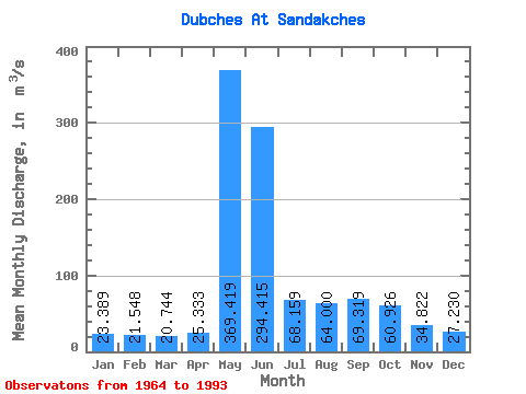
| Statistic | Jan | Feb | Mar | Apr | May | Jun | Jul | Aug | Sep | Oct | Nov | Dec | Annual |
|---|---|---|---|---|---|---|---|---|---|---|---|---|---|
| Mean | 23.39 | 21.55 | 20.74 | 25.33 | 369.42 | 294.42 | 68.16 | 64.00 | 69.32 | 60.93 | 34.82 | 27.23 | 89.94 |
| Standard Deviation | 3.51 | 3.15 | 2.83 | 8.65 | 128.05 | 165.15 | 25.38 | 37.14 | 30.60 | 26.50 | 8.40 | 5.08 | 16.27 |
| Min | 15.40 | 11.10 | 10.90 | 14.50 | 35.40 | 88.50 | 38.80 | 31.00 | 34.50 | 29.10 | 23.10 | 16.40 | 44.67 |
| Max | 32.20 | 28.00 | 25.30 | 50.00 | 619.00 | 865.00 | 140.00 | 219.00 | 136.00 | 109.00 | 52.40 | 39.30 | 115.57 |
| Coefficient of Variation | 0.15 | 0.15 | 0.14 | 0.34 | 0.35 | 0.56 | 0.37 | 0.58 | 0.44 | 0.43 | 0.24 | 0.19 | 0.18 |
 Return to R-Arctic Net Home Page