|
|
|||||||||||||||||
| Point ID: 6610 | Downloads | Plots | Site Data | Code: 9384 |
|
|
|||||||||||||||||
| Download | |
|---|---|
| Site Descriptor Information | Site Time Series Data |
| Link to all available data | |
| View: | Time Series | All |
| Units: | m3/s |
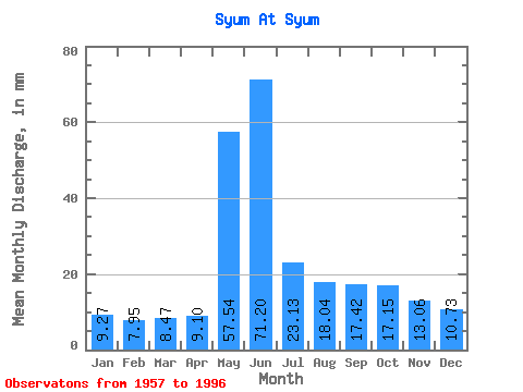
| Statistic | Jan | Feb | Mar | Apr | May | Jun | Jul | Aug | Sep | Oct | Nov | Dec | Annual |
|---|---|---|---|---|---|---|---|---|---|---|---|---|---|
| Mean | 9.27 | 8.02 | 8.47 | 9.10 | 57.53 | 71.20 | 23.12 | 18.03 | 17.41 | 17.15 | 13.06 | 10.73 | 261.88 |
| Standard Deviation | 1.84 | 1.25 | 1.02 | 1.48 | 18.48 | 26.75 | 6.62 | 5.40 | 5.72 | 5.59 | 3.77 | 2.60 | 35.57 |
| Min | 4.46 | 4.44 | 6.10 | 6.28 | 14.92 | 28.54 | 15.15 | 12.57 | 10.48 | 10.66 | 8.07 | 5.80 | 199.43 |
| Max | 15.50 | 10.81 | 10.20 | 13.64 | 93.26 | 123.92 | 50.62 | 37.00 | 30.92 | 28.89 | 24.67 | 20.79 | 333.88 |
| Coefficient of Variation | 0.20 | 0.16 | 0.12 | 0.16 | 0.32 | 0.38 | 0.29 | 0.30 | 0.33 | 0.33 | 0.29 | 0.24 | 0.14 |
 Return to R-Arctic Net Home Page