|
|
|||||||||||||||||
| Point ID: 6610 | Downloads | Plots | Site Data | Code: 9384 |
|
|
|||||||||||||||||
| Download | |
|---|---|
| Site Descriptor Information | Site Time Series Data |
| Link to all available data | |
| View: | Time Series | All |
| Units: | mm |
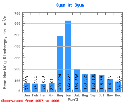
| Statistic | Jan | Feb | Mar | Apr | May | Jun | Jul | Aug | Sep | Oct | Nov | Dec | Annual |
|---|---|---|---|---|---|---|---|---|---|---|---|---|---|
| Mean | 78.93 | 74.96 | 72.08 | 80.01 | 489.82 | 626.26 | 196.89 | 153.53 | 153.19 | 145.99 | 114.86 | 91.36 | 189.19 |
| Standard Deviation | 15.64 | 11.68 | 8.69 | 13.03 | 157.32 | 235.34 | 56.36 | 46.01 | 50.28 | 47.62 | 33.19 | 22.11 | 25.70 |
| Min | 38.00 | 41.50 | 51.90 | 55.20 | 127.00 | 251.00 | 129.00 | 107.00 | 92.20 | 90.80 | 71.00 | 49.40 | 144.07 |
| Max | 132.00 | 101.00 | 86.80 | 120.00 | 794.00 | 1090.00 | 431.00 | 315.00 | 272.00 | 246.00 | 217.00 | 177.00 | 241.21 |
| Coefficient of Variation | 0.20 | 0.16 | 0.12 | 0.16 | 0.32 | 0.38 | 0.29 | 0.30 | 0.33 | 0.33 | 0.29 | 0.24 | 0.14 |
 Return to R-Arctic Net Home Page