|
|
|||||||||||||||||
| Point ID: 6608 | Downloads | Plots | Site Data | Code: 9378 |
|
|
|||||||||||||||||
| Download | |
|---|---|
| Site Descriptor Information | Site Time Series Data |
| Link to all available data | |
| View: | Time Series | All |
| Units: | m3/s |
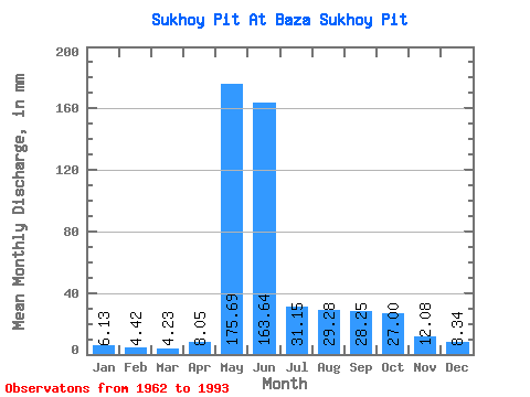
| Statistic | Jan | Feb | Mar | Apr | May | Jun | Jul | Aug | Sep | Oct | Nov | Dec | Annual |
|---|---|---|---|---|---|---|---|---|---|---|---|---|---|
| Mean | 6.12 | 4.46 | 4.23 | 8.05 | 175.66 | 163.64 | 31.14 | 29.27 | 28.25 | 27.00 | 12.08 | 8.34 | 496.28 |
| Standard Deviation | 2.12 | 1.49 | 1.48 | 6.69 | 48.65 | 71.85 | 9.50 | 29.13 | 15.38 | 16.04 | 4.91 | 2.92 | 85.88 |
| Min | 3.06 | 1.99 | 2.12 | 2.80 | 73.91 | 53.29 | 16.07 | 10.05 | 7.42 | 6.06 | 3.57 | 3.79 | 345.48 |
| Max | 10.95 | 7.91 | 8.10 | 30.90 | 274.23 | 325.56 | 55.92 | 164.32 | 64.49 | 63.20 | 23.22 | 13.75 | 681.59 |
| Coefficient of Variation | 0.35 | 0.33 | 0.35 | 0.83 | 0.28 | 0.44 | 0.30 | 0.99 | 0.54 | 0.59 | 0.41 | 0.35 | 0.17 |
 Return to R-Arctic Net Home Page