|
|
|||||||||||||||||
| Point ID: 6608 | Downloads | Plots | Site Data | Code: 9378 |
|
|
|||||||||||||||||
| Download | |
|---|---|
| Site Descriptor Information | Site Time Series Data |
| Link to all available data | |
|
|
| View: | Statistics | Time Series |
| Units: | m3/s |
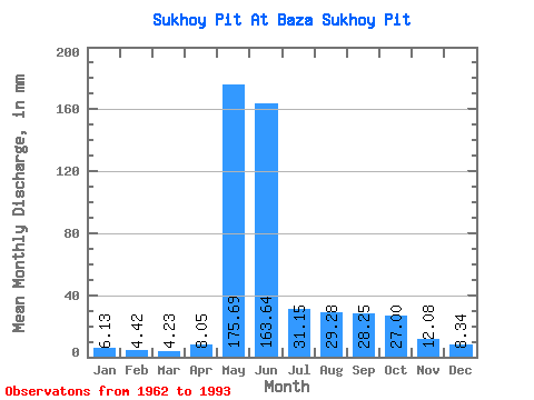
| Statistic | Jan | Feb | Mar | Apr | May | Jun | Jul | Aug | Sep | Oct | Nov | Dec | Annual |
|---|---|---|---|---|---|---|---|---|---|---|---|---|---|
| Mean | 6.12 | 4.46 | 4.23 | 8.05 | 175.66 | 163.64 | 31.14 | 29.27 | 28.25 | 27.00 | 12.08 | 8.34 | 496.28 |
| Standard Deviation | 2.12 | 1.49 | 1.48 | 6.69 | 48.65 | 71.85 | 9.50 | 29.13 | 15.38 | 16.04 | 4.91 | 2.92 | 85.88 |
| Min | 3.06 | 1.99 | 2.12 | 2.80 | 73.91 | 53.29 | 16.07 | 10.05 | 7.42 | 6.06 | 3.57 | 3.79 | 345.48 |
| Max | 10.95 | 7.91 | 8.10 | 30.90 | 274.23 | 325.56 | 55.92 | 164.32 | 64.49 | 63.20 | 23.22 | 13.75 | 681.59 |
| Coefficient of Variation | 0.35 | 0.33 | 0.35 | 0.83 | 0.28 | 0.44 | 0.30 | 0.99 | 0.54 | 0.59 | 0.41 | 0.35 | 0.17 |
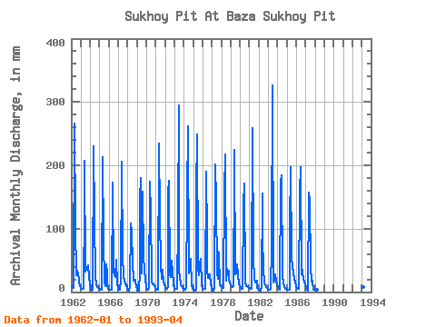
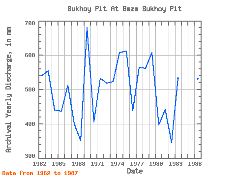
| Year | Jan | Feb | Mar | Apr | May | Jun | Jul | Aug | Sep | Oct | Nov | Dec | Annual | 1962 | 9.45 | 7.11 | 6.53 | 8.38 | 274.23 | 105.34 | 27.42 | 34.49 | 27.58 | 19.67 | 14.93 | 9.40 | 540.54 | 1963 | 6.73 | 5.02 | 4.65 | 4.42 | 139.26 | 206.53 | 33.42 | 37.71 | 37.95 | 43.70 | 23.22 | 12.23 | 554.24 | 1964 | 9.90 | 5.04 | 2.96 | 4.02 | 237.81 | 115.08 | 25.28 | 12.15 | 10.37 | 8.33 | 5.76 | 6.64 | 440.28 | 1965 | 5.38 | 3.81 | 3.88 | 5.47 | 220.67 | 82.94 | 16.07 | 10.09 | 43.96 | 31.49 | 10.66 | 5.55 | 437.11 | 1966 | 4.67 | 3.38 | 3.34 | 3.07 | 178.89 | 162.16 | 34.71 | 27.42 | 23.85 | 52.06 | 11.88 | 8.61 | 511.69 | 1967 | 4.71 | 3.44 | 3.81 | 19.93 | 213.17 | 54.74 | 29.57 | 25.07 | 19.72 | 12.38 | 12.53 | 4.88 | 400.52 | 1968 | 4.07 | 2.93 | 2.63 | 8.96 | 111.83 | 93.52 | 48.63 | 18.00 | 19.35 | 19.73 | 14.56 | 8.91 | 351.51 | 1969 | 4.20 | 2.56 | 2.12 | 30.90 | 149.75 | 179.37 | 31.07 | 164.32 | 55.16 | 36.63 | 18.62 | 9.66 | 681.59 | 1970 | 5.83 | 4.20 | 3.64 | 6.30 | 180.39 | 123.79 | 24.85 | 16.52 | 12.09 | 13.39 | 9.99 | 6.81 | 405.86 | 1971 | 3.75 | 3.48 | 3.36 | 4.25 | 242.09 | 119.44 | 43.28 | 21.40 | 34.84 | 33.64 | 15.24 | 12.00 | 533.13 | 1972 | 7.35 | 5.37 | 5.33 | 8.31 | 161.32 | 175.01 | 27.42 | 24.21 | 49.35 | 30.64 | 15.16 | 10.80 | 519.54 | 1973 | 6.06 | 4.29 | 4.78 | 5.62 | 116.33 | 294.45 | 31.49 | 26.99 | 10.51 | 9.23 | 6.57 | 5.36 | 523.10 | 1974 | 4.41 | 3.32 | 3.30 | 6.59 | 156.18 | 261.27 | 29.99 | 34.92 | 38.78 | 53.56 | 10.70 | 5.38 | 608.16 | 1975 | 4.63 | 3.30 | 2.87 | 3.36 | 162.39 | 248.83 | 40.06 | 27.21 | 44.58 | 54.42 | 11.18 | 9.68 | 611.88 | 1976 | 7.26 | 4.90 | 4.67 | 5.31 | 196.67 | 86.47 | 36.63 | 23.35 | 27.37 | 28.92 | 11.90 | 8.27 | 438.56 | 1977 | 3.51 | 1.99 | 2.83 | 7.13 | 208.03 | 143.91 | 30.42 | 22.07 | 64.49 | 63.20 | 10.62 | 9.62 | 565.20 | 1978 | 7.95 | 5.84 | 6.26 | 6.51 | 166.25 | 217.73 | 18.47 | 38.13 | 26.54 | 34.49 | 21.15 | 13.75 | 562.40 | 1979 | 10.95 | 7.46 | 8.10 | 8.94 | 197.96 | 223.95 | 28.92 | 29.78 | 43.13 | 26.78 | 12.17 | 10.11 | 607.45 | 1980 | 7.07 | 5.52 | 4.48 | 5.52 | 141.83 | 171.28 | 17.65 | 10.05 | 9.58 | 9.45 | 7.96 | 6.53 | 396.67 | 1981 | 6.23 | 4.96 | 4.52 | 24.88 | 267.80 | 53.29 | 20.95 | 16.26 | 16.11 | 18.90 | 6.84 | 5.27 | 441.80 | 1982 | 3.06 | 2.32 | 2.14 | 8.75 | 160.25 | 87.30 | 38.35 | 13.78 | 12.50 | 8.40 | 6.53 | 4.35 | 345.48 | 1983 | 4.01 | 3.57 | 3.41 | 4.56 | 73.91 | 325.56 | 22.50 | 15.47 | 19.62 | 29.14 | 16.90 | 12.21 | 533.62 | 1984 | 8.21 | 5.02 | 4.56 | 3.81 | 178.25 | 184.55 | 26.14 | 13.84 | 7.42 | 6.06 | 5.22 | 4.63 | 446.72 | 1985 | 4.11 | 3.57 | 3.47 | 4.29 | 107.12 | 197.82 | 55.92 | 40.28 | 31.10 | 21.04 | 14.41 | 10.09 | 492.80 | 1986 | 7.63 | 5.82 | 5.10 | 4.75 | 163.25 | 197.41 | 28.49 | 40.71 | 30.69 | 20.33 | 15.90 | 12.21 | 531.41 | 1987 | 7.26 | 4.61 | 4.18 | 2.80 | 161.54 | 142.87 | 41.99 | 16.93 | 17.77 | 16.45 | 3.57 | 3.79 | 422.04 | 1988 | 4.37 | 4.06 | 4.01 | 1993 | 8.72 | 7.91 | 7.50 | 10.47 |
|---|
 Return to R-Arctic Net Home Page