|
|
|||||||||||||||||
| Point ID: 6607 | Downloads | Plots | Site Data | Code: 9374 |
|
|
|||||||||||||||||
| Download | |
|---|---|
| Site Descriptor Information | Site Time Series Data |
| Link to all available data | |
| View: | Time Series | All |
| Units: | m3/s |
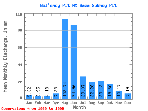
| Statistic | Jan | Feb | Mar | Apr | May | Jun | Jul | Aug | Sep | Oct | Nov | Dec | Annual |
|---|---|---|---|---|---|---|---|---|---|---|---|---|---|
| Mean | 5.32 | 3.98 | 4.13 | 7.23 | 102.73 | 94.96 | 29.06 | 22.28 | 23.12 | 19.60 | 10.17 | 7.19 | 330.47 |
| Standard Deviation | 1.94 | 1.65 | 1.65 | 7.22 | 25.43 | 33.53 | 6.96 | 11.54 | 10.23 | 9.43 | 6.88 | 2.63 | 55.75 |
| Min | 1.98 | 1.28 | 1.47 | 1.95 | 52.60 | 42.00 | 18.82 | 1.46 | 8.79 | 6.39 | 3.83 | 2.13 | 227.97 |
| Max | 12.26 | 10.23 | 9.13 | 42.00 | 156.56 | 199.38 | 48.34 | 60.29 | 45.19 | 38.18 | 41.87 | 13.29 | 474.83 |
| Coefficient of Variation | 0.36 | 0.41 | 0.40 | 1.00 | 0.25 | 0.35 | 0.24 | 0.52 | 0.44 | 0.48 | 0.68 | 0.36 | 0.17 |
 Return to R-Arctic Net Home Page