|
|
|||||||||||||||||
| Point ID: 6607 | Downloads | Plots | Site Data | Code: 9374 |
|
|
|||||||||||||||||
| Download | |
|---|---|
| Site Descriptor Information | Site Time Series Data |
| Link to all available data | |
| View: | Time Series | All |
| Units: | mm |
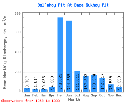
| Statistic | Jan | Feb | Mar | Apr | May | Jun | Jul | Aug | Sep | Oct | Nov | Dec | Annual |
|---|---|---|---|---|---|---|---|---|---|---|---|---|---|
| Mean | 38.77 | 31.81 | 30.08 | 54.36 | 748.03 | 714.39 | 211.61 | 162.20 | 173.97 | 142.72 | 76.53 | 52.35 | 204.19 |
| Standard Deviation | 14.13 | 13.15 | 12.00 | 54.35 | 185.19 | 252.27 | 50.68 | 84.06 | 76.99 | 68.69 | 51.75 | 19.12 | 34.45 |
| Min | 14.40 | 10.20 | 10.70 | 14.70 | 383.00 | 316.00 | 137.00 | 10.60 | 66.10 | 46.50 | 28.80 | 15.50 | 140.86 |
| Max | 89.30 | 81.80 | 66.50 | 316.00 | 1140.00 | 1500.00 | 352.00 | 439.00 | 340.00 | 278.00 | 315.00 | 96.80 | 293.38 |
| Coefficient of Variation | 0.36 | 0.41 | 0.40 | 1.00 | 0.25 | 0.35 | 0.24 | 0.52 | 0.44 | 0.48 | 0.68 | 0.36 | 0.17 |
 Return to R-Arctic Net Home Page