|
|
|||||||||||||||||
| Point ID: 6595 | Downloads | Plots | Site Data | Code: 9340 |
|
|
|||||||||||||||||
| Download | |
|---|---|
| Site Descriptor Information | Site Time Series Data |
| Link to all available data | |
| View: | Time Series | All |
| Units: | m3/s |
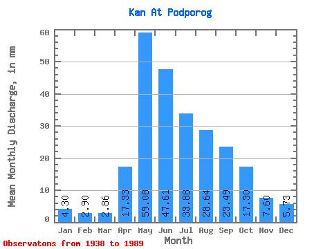
| Statistic | Jan | Feb | Mar | Apr | May | Jun | Jul | Aug | Sep | Oct | Nov | Dec | Annual |
|---|---|---|---|---|---|---|---|---|---|---|---|---|---|
| Mean | 4.30 | 2.93 | 2.86 | 17.32 | 59.07 | 47.61 | 33.87 | 28.63 | 23.49 | 17.30 | 7.60 | 5.72 | 251.59 |
| Standard Deviation | 1.32 | 0.92 | 0.94 | 9.53 | 18.80 | 15.47 | 10.97 | 11.20 | 8.01 | 6.43 | 2.76 | 1.67 | 49.91 |
| Min | 0.53 | 1.48 | 1.31 | 4.61 | 32.46 | 20.21 | 15.72 | 11.64 | 12.47 | 9.31 | 3.91 | 2.16 | 165.80 |
| Max | 7.79 | 6.83 | 7.05 | 44.87 | 129.53 | 102.13 | 65.28 | 71.61 | 44.59 | 37.99 | 14.79 | 12.01 | 376.80 |
| Coefficient of Variation | 0.31 | 0.31 | 0.33 | 0.55 | 0.32 | 0.33 | 0.32 | 0.39 | 0.34 | 0.37 | 0.36 | 0.29 | 0.20 |
 Return to R-Arctic Net Home Page