|
|
|||||||||||||||||
| Point ID: 6595 | Downloads | Plots | Site Data | Code: 9340 |
|
|
|||||||||||||||||
| Download | |
|---|---|
| Site Descriptor Information | Site Time Series Data |
| Link to all available data | |
| View: | Time Series | All |
| Units: | mm |
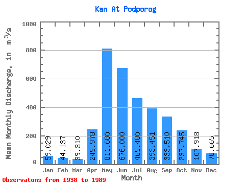
| Statistic | Jan | Feb | Mar | Apr | May | Jun | Jul | Aug | Sep | Oct | Nov | Dec | Annual |
|---|---|---|---|---|---|---|---|---|---|---|---|---|---|
| Mean | 59.03 | 44.14 | 39.31 | 245.98 | 811.68 | 676.00 | 465.48 | 393.45 | 333.51 | 237.75 | 107.92 | 78.67 | 293.37 |
| Standard Deviation | 18.15 | 13.87 | 12.92 | 135.31 | 258.38 | 219.71 | 150.69 | 153.84 | 113.73 | 88.38 | 39.24 | 22.91 | 58.19 |
| Min | 7.29 | 22.30 | 18.00 | 65.50 | 446.00 | 287.00 | 216.00 | 160.00 | 177.00 | 128.00 | 55.50 | 29.70 | 193.33 |
| Max | 107.00 | 103.00 | 96.90 | 637.00 | 1780.00 | 1450.00 | 897.00 | 984.00 | 633.00 | 522.00 | 210.00 | 165.00 | 439.36 |
| Coefficient of Variation | 0.31 | 0.31 | 0.33 | 0.55 | 0.32 | 0.33 | 0.32 | 0.39 | 0.34 | 0.37 | 0.36 | 0.29 | 0.20 |
 Return to R-Arctic Net Home Page