|
|
|||||||||||||||||
| Point ID: 6594 | Downloads | Plots | Site Data | Code: 9337 |
|
|
|||||||||||||||||
| Download | |
|---|---|
| Site Descriptor Information | Site Time Series Data |
| Link to all available data | |
| View: | Time Series | All |
| Units: | m3/s |
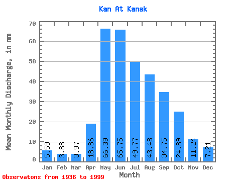
| Statistic | Jan | Feb | Mar | Apr | May | Jun | Jul | Aug | Sep | Oct | Nov | Dec | Annual |
|---|---|---|---|---|---|---|---|---|---|---|---|---|---|
| Mean | 5.59 | 3.91 | 3.97 | 18.86 | 66.38 | 65.75 | 49.76 | 43.47 | 34.75 | 24.89 | 11.24 | 7.21 | 334.46 |
| Standard Deviation | 1.29 | 0.96 | 1.01 | 11.09 | 22.36 | 20.90 | 15.25 | 18.75 | 11.78 | 9.02 | 12.19 | 1.57 | 66.93 |
| Min | 2.71 | 1.48 | 1.46 | 3.69 | 32.48 | 31.10 | 22.82 | 14.67 | 12.62 | 10.41 | 4.47 | 3.96 | 185.01 |
| Max | 9.14 | 5.73 | 6.54 | 46.77 | 137.39 | 126.22 | 99.55 | 119.93 | 63.56 | 45.88 | 102.33 | 11.12 | 503.12 |
| Coefficient of Variation | 0.23 | 0.24 | 0.26 | 0.59 | 0.34 | 0.32 | 0.31 | 0.43 | 0.34 | 0.36 | 1.08 | 0.22 | 0.20 |
 Return to R-Arctic Net Home Page