|
|
|||||||||||||||||
| Point ID: 6594 | Downloads | Plots | Site Data | Code: 9337 |
|
|
|||||||||||||||||
| Download | |
|---|---|
| Site Descriptor Information | Site Time Series Data |
| Link to all available data | |
| View: | Time Series | All |
| Units: | mm |
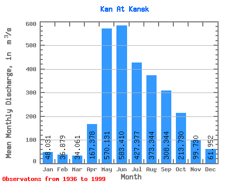
| Statistic | Jan | Feb | Mar | Apr | May | Jun | Jul | Aug | Sep | Oct | Nov | Dec | Annual |
|---|---|---|---|---|---|---|---|---|---|---|---|---|---|
| Mean | 48.03 | 36.88 | 34.06 | 167.38 | 570.13 | 583.41 | 427.38 | 373.34 | 308.34 | 213.73 | 99.73 | 61.95 | 243.75 |
| Standard Deviation | 11.06 | 9.03 | 8.69 | 98.44 | 192.02 | 185.48 | 131.00 | 160.99 | 104.50 | 77.50 | 108.17 | 13.45 | 48.78 |
| Min | 23.30 | 13.90 | 12.50 | 32.70 | 279.00 | 276.00 | 196.00 | 126.00 | 112.00 | 89.40 | 39.70 | 34.00 | 134.83 |
| Max | 78.50 | 54.00 | 56.20 | 415.00 | 1180.00 | 1120.00 | 855.00 | 1030.00 | 564.00 | 394.00 | 908.00 | 95.50 | 366.66 |
| Coefficient of Variation | 0.23 | 0.24 | 0.26 | 0.59 | 0.34 | 0.32 | 0.31 | 0.43 | 0.34 | 0.36 | 1.08 | 0.22 | 0.20 |
 Return to R-Arctic Net Home Page