|
|
|||||||||||||||||
| Point ID: 6593 | Downloads | Plots | Site Data | Code: 9335 |
|
|
|||||||||||||||||
| Download | |
|---|---|
| Site Descriptor Information | Site Time Series Data |
| Link to all available data | |
| View: | Time Series | All |
| Units: | m3/s |
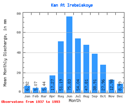
| Statistic | Jan | Feb | Mar | Apr | May | Jun | Jul | Aug | Sep | Oct | Nov | Dec | Annual |
|---|---|---|---|---|---|---|---|---|---|---|---|---|---|
| Mean | 6.92 | 5.11 | 5.44 | 17.27 | 51.19 | 75.83 | 54.04 | 47.81 | 38.91 | 27.95 | 12.98 | 8.99 | 352.25 |
| Standard Deviation | 1.29 | 1.14 | 1.17 | 6.13 | 15.98 | 21.56 | 15.96 | 17.77 | 11.94 | 10.09 | 4.32 | 2.06 | 64.96 |
| Min | 4.46 | 3.17 | 2.80 | 6.25 | 26.04 | 36.60 | 27.70 | 15.28 | 18.63 | 16.30 | 6.13 | 5.23 | 221.51 |
| Max | 10.21 | 7.28 | 7.84 | 29.40 | 102.69 | 139.57 | 85.47 | 110.99 | 64.28 | 57.19 | 24.37 | 15.40 | 572.77 |
| Coefficient of Variation | 0.19 | 0.22 | 0.22 | 0.35 | 0.31 | 0.28 | 0.29 | 0.37 | 0.31 | 0.36 | 0.33 | 0.23 | 0.18 |
 Return to R-Arctic Net Home Page