|
|
|||||||||||||||||
| Point ID: 6593 | Downloads | Plots | Site Data | Code: 9335 |
|
|
|||||||||||||||||
| Download | |
|---|---|
| Site Descriptor Information | Site Time Series Data |
| Link to all available data | |
| View: | Time Series | All |
| Units: | mm |
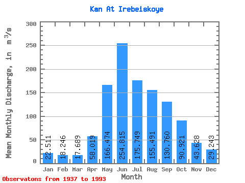
| Statistic | Jan | Feb | Mar | Apr | May | Jun | Jul | Aug | Sep | Oct | Nov | Dec | Annual |
|---|---|---|---|---|---|---|---|---|---|---|---|---|---|
| Mean | 22.51 | 18.25 | 17.69 | 58.02 | 166.47 | 254.81 | 175.75 | 155.49 | 130.76 | 90.92 | 43.63 | 29.24 | 97.21 |
| Standard Deviation | 4.20 | 4.07 | 3.81 | 20.60 | 51.98 | 72.46 | 51.90 | 57.81 | 40.11 | 32.82 | 14.51 | 6.70 | 17.93 |
| Min | 14.50 | 11.30 | 9.11 | 21.00 | 84.70 | 123.00 | 90.10 | 49.70 | 62.60 | 53.00 | 20.60 | 17.00 | 61.13 |
| Max | 33.20 | 26.00 | 25.50 | 98.80 | 334.00 | 469.00 | 278.00 | 361.00 | 216.00 | 186.00 | 81.90 | 50.10 | 158.07 |
| Coefficient of Variation | 0.19 | 0.22 | 0.22 | 0.35 | 0.31 | 0.28 | 0.29 | 0.37 | 0.31 | 0.36 | 0.33 | 0.23 | 0.18 |
 Return to R-Arctic Net Home Page