|
|
|||||||||||||||||
| Point ID: 6592 | Downloads | Plots | Site Data | Code: 9333 |
|
|
|||||||||||||||||
| Download | |
|---|---|
| Site Descriptor Information | Site Time Series Data |
| Link to all available data | |
| View: | Time Series | All |
| Units: | m3/s |
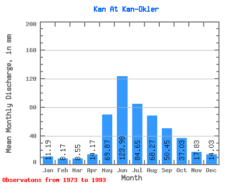
| Statistic | Jan | Feb | Mar | Apr | May | Jun | Jul | Aug | Sep | Oct | Nov | Dec | Annual |
|---|---|---|---|---|---|---|---|---|---|---|---|---|---|
| Mean | 11.19 | 8.24 | 8.55 | 14.17 | 69.86 | 123.98 | 84.64 | 68.26 | 50.45 | 37.02 | 17.83 | 14.03 | 506.63 |
| Standard Deviation | 2.25 | 1.73 | 1.66 | 5.24 | 24.73 | 33.86 | 24.74 | 24.41 | 17.92 | 15.02 | 5.44 | 4.11 | 93.89 |
| Min | 6.32 | 5.57 | 5.76 | 5.86 | 34.08 | 65.73 | 48.63 | 27.23 | 24.25 | 15.25 | 9.98 | 7.82 | 371.54 |
| Max | 15.63 | 11.44 | 10.83 | 25.80 | 132.62 | 220.13 | 131.34 | 124.93 | 94.88 | 83.93 | 32.87 | 22.23 | 672.54 |
| Coefficient of Variation | 0.20 | 0.21 | 0.19 | 0.37 | 0.35 | 0.27 | 0.29 | 0.36 | 0.35 | 0.41 | 0.30 | 0.29 | 0.18 |
 Return to R-Arctic Net Home Page