|
|
|||||||||||||||||
| Point ID: 6592 | Downloads | Plots | Site Data | Code: 9333 |
|
|
|||||||||||||||||
| Download | |
|---|---|
| Site Descriptor Information | Site Time Series Data |
| Link to all available data | |
| View: | Time Series | All |
| Units: | mm |
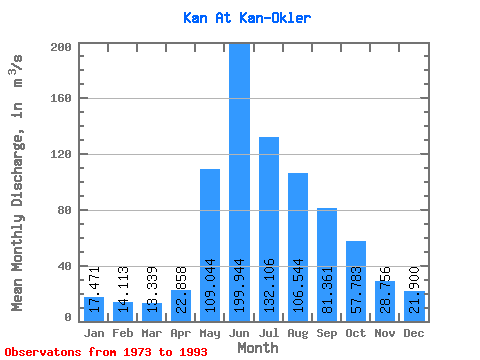
| Statistic | Jan | Feb | Mar | Apr | May | Jun | Jul | Aug | Sep | Oct | Nov | Dec | Annual |
|---|---|---|---|---|---|---|---|---|---|---|---|---|---|
| Mean | 17.47 | 14.11 | 13.34 | 22.86 | 109.04 | 199.94 | 132.11 | 106.54 | 81.36 | 57.78 | 28.76 | 21.90 | 67.10 |
| Standard Deviation | 3.51 | 2.97 | 2.58 | 8.45 | 38.60 | 54.60 | 38.61 | 38.11 | 28.89 | 23.44 | 8.77 | 6.41 | 12.44 |
| Min | 9.87 | 9.54 | 8.99 | 9.45 | 53.20 | 106.00 | 75.90 | 42.50 | 39.10 | 23.80 | 16.10 | 12.20 | 49.21 |
| Max | 24.40 | 19.60 | 16.90 | 41.60 | 207.00 | 355.00 | 205.00 | 195.00 | 153.00 | 131.00 | 53.00 | 34.70 | 89.08 |
| Coefficient of Variation | 0.20 | 0.21 | 0.19 | 0.37 | 0.35 | 0.27 | 0.29 | 0.36 | 0.35 | 0.41 | 0.30 | 0.29 | 0.18 |
 Return to R-Arctic Net Home Page