|
|
|||||||||||||||||
| Point ID: 6591 | Downloads | Plots | Site Data | Code: 9329 |
|
|
|||||||||||||||||
| Download | |
|---|---|
| Site Descriptor Information | Site Time Series Data |
| Link to all available data | |
| View: | Time Series | All |
| Units: | m3/s |
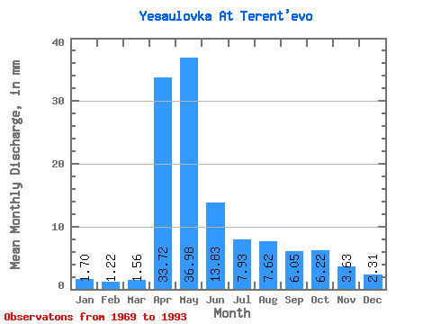
| Statistic | Jan | Feb | Mar | Apr | May | Jun | Jul | Aug | Sep | Oct | Nov | Dec | Annual |
|---|---|---|---|---|---|---|---|---|---|---|---|---|---|
| Mean | 1.70 | 1.23 | 1.56 | 33.72 | 36.98 | 13.83 | 7.93 | 7.61 | 6.05 | 6.22 | 3.63 | 2.31 | 122.42 |
| Standard Deviation | 1.11 | 0.90 | 0.99 | 16.44 | 14.20 | 6.65 | 4.96 | 5.64 | 3.49 | 3.72 | 1.76 | 1.19 | 42.39 |
| Min | 0.24 | 0.20 | 0.28 | 13.79 | 12.95 | 5.52 | 3.52 | 2.75 | 2.65 | 2.81 | 1.21 | 0.77 | 58.91 |
| Max | 3.96 | 3.53 | 3.92 | 72.97 | 59.61 | 27.87 | 26.60 | 27.51 | 16.44 | 16.66 | 7.01 | 4.92 | 255.88 |
| Coefficient of Variation | 0.65 | 0.74 | 0.64 | 0.49 | 0.38 | 0.48 | 0.63 | 0.74 | 0.58 | 0.60 | 0.48 | 0.52 | 0.35 |
 Return to R-Arctic Net Home Page