|
|
|||||||||||||||||
| Point ID: 6591 | Downloads | Plots | Site Data | Code: 9329 |
|
|
|||||||||||||||||
| Download | |
|---|---|
| Site Descriptor Information | Site Time Series Data |
| Link to all available data | |
| View: | Time Series | All |
| Units: | mm |
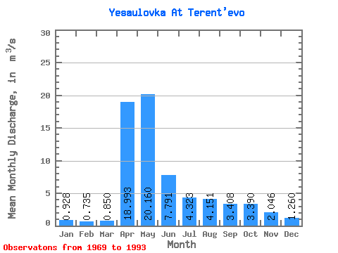
| Statistic | Jan | Feb | Mar | Apr | May | Jun | Jul | Aug | Sep | Oct | Nov | Dec | Annual |
|---|---|---|---|---|---|---|---|---|---|---|---|---|---|
| Mean | 0.93 | 0.73 | 0.85 | 18.99 | 20.16 | 7.79 | 4.32 | 4.15 | 3.41 | 3.39 | 2.05 | 1.26 | 5.66 |
| Standard Deviation | 0.61 | 0.54 | 0.54 | 9.26 | 7.74 | 3.75 | 2.70 | 3.08 | 1.97 | 2.03 | 0.99 | 0.65 | 1.96 |
| Min | 0.13 | 0.12 | 0.15 | 7.77 | 7.06 | 3.11 | 1.92 | 1.50 | 1.49 | 1.53 | 0.68 | 0.42 | 2.73 |
| Max | 2.16 | 2.11 | 2.14 | 41.10 | 32.50 | 15.70 | 14.50 | 15.00 | 9.26 | 9.08 | 3.95 | 2.68 | 11.84 |
| Coefficient of Variation | 0.65 | 0.74 | 0.64 | 0.49 | 0.38 | 0.48 | 0.63 | 0.74 | 0.58 | 0.60 | 0.48 | 0.52 | 0.35 |
 Return to R-Arctic Net Home Page