|
|
|||||||||||||||||
| Point ID: 6583 | Downloads | Plots | Site Data | Code: 9285 |
|
|
|||||||||||||||||
| Download | |
|---|---|
| Site Descriptor Information | Site Time Series Data |
| Link to all available data | |
| View: | Time Series | All |
| Units: | m3/s |
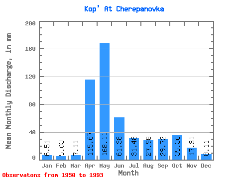
| Statistic | Jan | Feb | Mar | Apr | May | Jun | Jul | Aug | Sep | Oct | Nov | Dec | Annual |
|---|---|---|---|---|---|---|---|---|---|---|---|---|---|
| Mean | 6.51 | 5.08 | 7.11 | 115.67 | 168.08 | 61.38 | 31.48 | 27.97 | 29.72 | 35.35 | 17.31 | 8.11 | 517.60 |
| Standard Deviation | 1.91 | 1.50 | 2.71 | 45.05 | 64.41 | 31.30 | 23.72 | 16.73 | 19.68 | 21.96 | 11.88 | 2.61 | 113.42 |
| Min | 3.66 | 3.00 | 3.07 | 37.03 | 64.23 | 16.65 | 8.88 | 6.23 | 8.11 | 11.09 | 5.62 | 4.02 | 304.90 |
| Max | 10.89 | 9.95 | 14.19 | 242.44 | 376.99 | 147.03 | 132.09 | 74.28 | 102.71 | 82.38 | 53.79 | 15.13 | 735.30 |
| Coefficient of Variation | 0.29 | 0.30 | 0.38 | 0.39 | 0.38 | 0.51 | 0.75 | 0.60 | 0.66 | 0.62 | 0.69 | 0.32 | 0.22 |
 Return to R-Arctic Net Home Page