|
|
|||||||||||||||||
| Point ID: 6583 | Downloads | Plots | Site Data | Code: 9285 |
|
|
|||||||||||||||||
| Download | |
|---|---|
| Site Descriptor Information | Site Time Series Data |
| Link to all available data | |
|
|
| View: | Statistics | Time Series |
| Units: | m3/s |
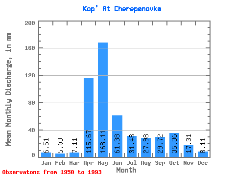
| Statistic | Jan | Feb | Mar | Apr | May | Jun | Jul | Aug | Sep | Oct | Nov | Dec | Annual |
|---|---|---|---|---|---|---|---|---|---|---|---|---|---|
| Mean | 6.51 | 5.08 | 7.11 | 115.67 | 168.08 | 61.38 | 31.48 | 27.97 | 29.72 | 35.35 | 17.31 | 8.11 | 517.60 |
| Standard Deviation | 1.91 | 1.50 | 2.71 | 45.05 | 64.41 | 31.30 | 23.72 | 16.73 | 19.68 | 21.96 | 11.88 | 2.61 | 113.42 |
| Min | 3.66 | 3.00 | 3.07 | 37.03 | 64.23 | 16.65 | 8.88 | 6.23 | 8.11 | 11.09 | 5.62 | 4.02 | 304.90 |
| Max | 10.89 | 9.95 | 14.19 | 242.44 | 376.99 | 147.03 | 132.09 | 74.28 | 102.71 | 82.38 | 53.79 | 15.13 | 735.30 |
| Coefficient of Variation | 0.29 | 0.30 | 0.38 | 0.39 | 0.38 | 0.51 | 0.75 | 0.60 | 0.66 | 0.62 | 0.69 | 0.32 | 0.22 |
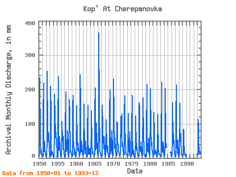
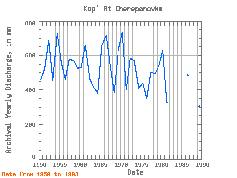
| Year | Jan | Feb | Mar | Apr | May | Jun | Jul | Aug | Sep | Oct | Nov | Dec | Annual | 1950 | 5.22 | 4.12 | 6.03 | 59.73 | 240.71 | 54.06 | 12.31 | 18.99 | 25.60 | 23.68 | 7.05 | 5.05 | 459.44 | 1951 | 5.17 | 4.15 | 5.25 | 121.90 | 225.91 | 42.43 | 19.57 | 49.43 | 22.62 | 17.37 | 9.78 | 6.79 | 527.67 | 1952 | 4.89 | 3.00 | 3.07 | 57.30 | 261.94 | 80.54 | 73.16 | 52.50 | 46.76 | 75.12 | 25.54 | 7.65 | 686.21 | 1953 | 5.67 | 4.76 | 5.89 | 208.12 | 127.62 | 28.38 | 8.88 | 17.87 | 19.24 | 16.06 | 9.03 | 5.36 | 457.77 | 1954 | 4.44 | 3.89 | 3.80 | 72.71 | 191.84 | 119.19 | 76.51 | 61.16 | 74.06 | 61.71 | 53.79 | 7.85 | 728.64 | 1955 | 4.22 | 3.33 | 3.83 | 103.25 | 245.74 | 43.79 | 24.02 | 23.54 | 62.16 | 30.72 | 11.78 | 7.34 | 561.13 | 1956 | 3.69 | 3.69 | 5.05 | 106.49 | 98.30 | 61.35 | 40.77 | 26.39 | 62.16 | 36.30 | 14.27 | 5.08 | 463.56 | 1957 | 4.36 | 3.21 | 4.27 | 71.35 | 199.66 | 85.95 | 19.63 | 41.33 | 25.14 | 82.10 | 32.70 | 11.90 | 578.49 | 1958 | 8.13 | 5.45 | 4.80 | 143.25 | 175.65 | 130.00 | 21.78 | 17.54 | 21.65 | 19.07 | 14.30 | 7.29 | 569.30 | 1959 | 6.34 | 4.91 | 8.54 | 152.17 | 188.77 | 57.84 | 39.93 | 18.49 | 11.38 | 24.57 | 9.19 | 7.09 | 527.73 | 1960 | 6.73 | 5.24 | 5.31 | 152.17 | 140.18 | 55.68 | 21.34 | 34.91 | 43.24 | 27.65 | 27.57 | 11.64 | 531.70 | 1961 | 8.15 | 6.84 | 9.97 | 242.44 | 168.39 | 83.52 | 19.13 | 18.35 | 48.38 | 29.32 | 16.24 | 10.11 | 662.38 | 1962 | 7.57 | 5.85 | 13.35 | 157.03 | 136.27 | 28.65 | 18.93 | 14.27 | 14.62 | 50.82 | 12.70 | 8.46 | 467.64 | 1963 | 6.28 | 4.02 | 6.23 | 76.76 | 159.45 | 51.89 | 15.95 | 11.25 | 19.27 | 25.64 | 28.38 | 12.06 | 415.84 | 1964 | 7.96 | 4.10 | 6.31 | 95.14 | 141.58 | 39.19 | 14.13 | 18.82 | 17.46 | 12.46 | 12.24 | 11.14 | 379.44 | 1965 | 8.01 | 5.27 | 13.43 | 135.68 | 210.83 | 22.70 | 29.60 | 31.00 | 102.71 | 44.12 | 43.24 | 12.31 | 657.53 | 1966 | 9.30 | 7.23 | 6.39 | 81.36 | 376.99 | 147.03 | 27.93 | 24.27 | 14.24 | 14.94 | 8.73 | 5.84 | 720.14 | 1967 | 5.00 | 5.01 | 7.32 | 154.33 | 87.68 | 70.00 | 59.48 | 28.76 | 39.73 | 63.95 | 11.11 | 9.36 | 541.47 | 1968 | 6.81 | 3.66 | 8.77 | 110.55 | 112.82 | 31.35 | 18.18 | 19.83 | 34.60 | 20.83 | 11.11 | 6.84 | 384.90 | 1969 | 5.61 | 3.82 | 3.71 | 141.09 | 204.41 | 67.30 | 14.58 | 26.95 | 37.03 | 82.38 | 22.62 | 10.97 | 618.45 | 1970 | 7.04 | 5.55 | 6.14 | 150.82 | 237.08 | 123.52 | 28.48 | 41.05 | 47.30 | 60.88 | 19.70 | 9.30 | 735.30 | 1971 | 7.79 | 6.87 | 7.90 | 105.41 | 103.60 | 38.92 | 45.80 | 35.47 | 18.97 | 15.53 | 10.57 | 6.45 | 402.37 | 1972 | 6.12 | 4.91 | 14.19 | 120.55 | 64.23 | 86.49 | 132.09 | 36.30 | 33.24 | 46.91 | 26.95 | 12.76 | 583.43 | 1973 | 10.36 | 9.21 | 9.21 | 132.17 | 187.10 | 101.36 | 41.89 | 34.07 | 13.92 | 13.40 | 9.43 | 7.46 | 568.62 | 1974 | 6.59 | 5.22 | 6.12 | 129.19 | 89.92 | 26.97 | 10.50 | 6.23 | 25.46 | 79.86 | 20.14 | 6.20 | 412.08 | 1975 | 5.50 | 4.63 | 7.99 | 76.76 | 188.21 | 81.89 | 15.33 | 9.86 | 23.79 | 17.98 | 6.87 | 4.02 | 441.50 | 1976 | 3.66 | 3.89 | 4.08 | 64.06 | 126.78 | 28.38 | 23.15 | 45.80 | 17.57 | 20.47 | 7.22 | 5.45 | 348.40 | 1977 | 4.16 | 3.38 | 7.51 | 161.63 | 152.47 | 37.57 | 24.07 | 18.32 | 20.87 | 48.87 | 15.70 | 10.33 | 503.84 | 1978 | 8.63 | 5.88 | 8.46 | 175.68 | 160.57 | 77.57 | 15.47 | 13.07 | 8.11 | 11.09 | 5.62 | 4.89 | 495.42 | 1979 | 4.33 | 4.15 | 5.17 | 64.87 | 220.89 | 46.49 | 23.65 | 18.32 | 27.57 | 59.48 | 53.24 | 15.13 | 540.21 | 1980 | 9.44 | 6.74 | 7.26 | 132.17 | 208.60 | 78.92 | 36.02 | 61.99 | 32.97 | 28.20 | 17.24 | 8.99 | 626.46 | 1981 | 6.70 | 5.27 | 8.49 | 132.71 | 74.84 | 16.65 | 13.77 | 12.87 | 16.59 | 24.02 | 8.84 | 6.62 | 327.69 | 1982 | 5.39 | 4.83 | 5.33 | 127.57 | 121.47 | 17.70 | 21.22 | 14.63 | 10.92 | 1983 | 6.09 | 37.03 | 228.71 | 75.14 | 20.36 | 16.98 | 30.00 | 48.87 | 25.70 | 8.21 | 1984 | 6.03 | 4.66 | 6.12 | 40.27 | 210.28 | 56.76 | 33.79 | 1985 | 17.29 | 11.43 | 7.26 | 1986 | 6.03 | 5.22 | 6.87 | 58.65 | 166.99 | 50.81 | 43.00 | 74.28 | 33.24 | 25.27 | 13.14 | 7.15 | 487.44 | 1987 | 5.36 | 5.29 | 6.37 | 116.49 | 219.77 | 62.44 | 43.00 | 14.58 | 16.59 | 54.73 | 11.43 | 5.11 | 558.36 | 1988 | 10.42 | 6.36 | 7.29 | 160.28 | 95.78 | 47.57 | 73.44 | 55.85 | 14.49 | 11.70 | 7.76 | 6.48 | 496.60 | 1989 | 5.81 | 4.40 | 12.18 | 84.33 | 80.42 | 51.08 | 19.05 | 11.34 | 9.30 | 11.25 | 9.60 | 6.17 | 304.90 | 1993 | 10.89 | 9.95 | 10.14 | 113.25 | 90.76 | 48.11 | 19.27 | 14.30 | 16.24 | 24.24 | 13.27 | 8.18 | 378.98 |
|---|
 Return to R-Arctic Net Home Page