|
|
|||||||||||||||||
| Point ID: 6579 | Downloads | Plots | Site Data | Code: 9264 |
|
|
|||||||||||||||||
| Download | |
|---|---|
| Site Descriptor Information | Site Time Series Data |
| Link to all available data | |
| View: | Time Series | All |
| Units: | m3/s |
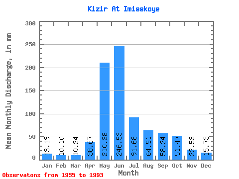
| Statistic | Jan | Feb | Mar | Apr | May | Jun | Jul | Aug | Sep | Oct | Nov | Dec | Annual |
|---|---|---|---|---|---|---|---|---|---|---|---|---|---|
| Mean | 13.19 | 10.18 | 10.24 | 38.66 | 210.34 | 246.53 | 91.67 | 64.50 | 58.24 | 51.47 | 22.54 | 15.73 | 831.26 |
| Standard Deviation | 2.41 | 1.70 | 2.03 | 17.58 | 50.35 | 78.72 | 24.33 | 26.26 | 28.06 | 19.69 | 6.53 | 3.50 | 119.23 |
| Min | 6.34 | 6.85 | 6.43 | 10.36 | 119.74 | 115.04 | 55.74 | 31.56 | 25.75 | 21.27 | 12.02 | 9.41 | 604.99 |
| Max | 18.05 | 13.97 | 15.54 | 67.94 | 386.36 | 473.87 | 161.62 | 136.26 | 161.86 | 114.43 | 36.54 | 24.45 | 1066.97 |
| Coefficient of Variation | 0.18 | 0.17 | 0.20 | 0.46 | 0.24 | 0.32 | 0.27 | 0.41 | 0.48 | 0.38 | 0.29 | 0.22 | 0.14 |
 Return to R-Arctic Net Home Page