|
|
|||||||||||||||||
| Point ID: 6579 | Downloads | Plots | Site Data | Code: 9264 |
|
|
|||||||||||||||||
| Download | |
|---|---|
| Site Descriptor Information | Site Time Series Data |
| Link to all available data | |
|
|
| View: | Statistics | Time Series |
| Units: | m3/s |
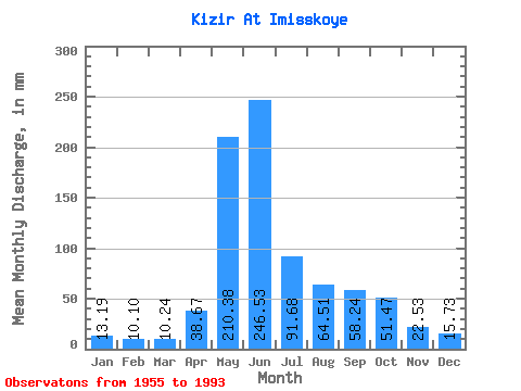
| Statistic | Jan | Feb | Mar | Apr | May | Jun | Jul | Aug | Sep | Oct | Nov | Dec | Annual |
|---|---|---|---|---|---|---|---|---|---|---|---|---|---|
| Mean | 13.19 | 10.18 | 10.24 | 38.66 | 210.34 | 246.53 | 91.67 | 64.50 | 58.24 | 51.47 | 22.54 | 15.73 | 831.26 |
| Standard Deviation | 2.41 | 1.70 | 2.03 | 17.58 | 50.35 | 78.72 | 24.33 | 26.26 | 28.06 | 19.69 | 6.53 | 3.50 | 119.23 |
| Min | 6.34 | 6.85 | 6.43 | 10.36 | 119.74 | 115.04 | 55.74 | 31.56 | 25.75 | 21.27 | 12.02 | 9.41 | 604.99 |
| Max | 18.05 | 13.97 | 15.54 | 67.94 | 386.36 | 473.87 | 161.62 | 136.26 | 161.86 | 114.43 | 36.54 | 24.45 | 1066.97 |
| Coefficient of Variation | 0.18 | 0.17 | 0.20 | 0.46 | 0.24 | 0.32 | 0.27 | 0.41 | 0.48 | 0.38 | 0.29 | 0.22 | 0.14 |
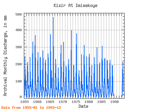
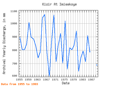
| Year | Jan | Feb | Mar | Apr | May | Jun | Jul | Aug | Sep | Oct | Nov | Dec | Annual | 1955 | 13.83 | 11.39 | 11.09 | 29.12 | 193.48 | 245.21 | 97.62 | 54.86 | 133.60 | 73.44 | 21.30 | 11.83 | 895.76 | 1956 | 11.32 | 9.32 | 7.88 | 38.82 | 174.60 | 210.39 | 98.21 | 61.05 | 74.79 | 75.50 | 31.40 | 12.68 | 804.00 | 1957 | 13.63 | 9.84 | 8.52 | 17.01 | 140.98 | 238.36 | 70.19 | 99.69 | 70.22 | 79.93 | 36.54 | 20.82 | 804.03 | 1958 | 14.42 | 11.37 | 10.15 | 25.32 | 202.62 | 331.14 | 87.59 | 44.53 | 43.39 | 37.46 | 23.69 | 13.54 | 844.96 | 1959 | 12.51 | 10.45 | 11.59 | 43.10 | 261.02 | 368.25 | 108.24 | 57.51 | 43.10 | 59.58 | 17.93 | 16.10 | 1007.68 | 1960 | 12.92 | 10.21 | 10.47 | 36.54 | 176.37 | 267.19 | 100.28 | 131.25 | 71.65 | 43.65 | 24.26 | 14.92 | 897.59 | 1961 | 14.69 | 8.65 | 7.67 | 67.94 | 239.19 | 240.36 | 90.84 | 48.66 | 81.64 | 50.43 | 18.75 | 17.11 | 884.21 | 1962 | 12.30 | 8.46 | 9.56 | 54.81 | 288.15 | 192.97 | 71.08 | 48.37 | 47.39 | 63.71 | 22.81 | 17.96 | 833.72 | 1963 | 12.36 | 10.51 | 10.91 | 16.39 | 200.56 | 225.23 | 91.72 | 44.24 | 56.24 | 37.16 | 24.61 | 14.36 | 742.45 | 1964 | 15.22 | 11.90 | 11.74 | 19.58 | 268.98 | 214.38 | 74.03 | 52.20 | 49.67 | 31.56 | 20.95 | 19.14 | 786.28 | 1965 | 13.36 | 10.96 | 10.23 | 32.54 | 386.36 | 174.42 | 72.85 | 61.94 | 161.86 | 80.22 | 29.69 | 14.19 | 1043.86 | 1966 | 13.65 | 10.13 | 10.88 | 18.81 | 228.28 | 473.87 | 140.09 | 75.21 | 42.25 | 32.44 | 12.28 | 9.41 | 1066.97 | 1967 | 11.38 | 8.84 | 9.32 | 63.09 | 235.36 | 163.00 | 84.65 | 52.50 | 66.51 | 53.68 | 21.67 | 15.28 | 782.28 | 1968 | 14.45 | 11.31 | 12.68 | 55.09 | 184.04 | 124.46 | 59.58 | 41.00 | 37.11 | 35.98 | 15.50 | 16.02 | 604.99 | 1969 | 12.48 | 8.01 | 8.44 | 28.15 | 219.14 | 311.15 | 59.58 | 47.19 | 63.09 | 65.77 | 20.98 | 16.61 | 859.70 | 1970 | 17.61 | 12.60 | 11.97 | 41.68 | 274.88 | 328.28 | 106.18 | 87.30 | 71.37 | 68.72 | 26.66 | 18.73 | 1063.33 | 1971 | 16.43 | 13.97 | 12.03 | 56.81 | 195.84 | 172.13 | 92.31 | 53.97 | 42.82 | 29.46 | 16.56 | 13.27 | 713.52 | 1972 | 12.39 | 9.03 | 12.03 | 62.80 | 166.34 | 228.37 | 104.70 | 89.36 | 72.22 | 48.07 | 17.81 | 15.48 | 836.88 | 1973 | 14.28 | 11.34 | 10.91 | 39.97 | 171.06 | 396.79 | 128.89 | 62.53 | 32.26 | 24.60 | 16.70 | 16.37 | 926.00 | 1974 | 14.87 | 10.91 | 10.23 | 63.37 | 198.20 | 192.97 | 60.17 | 31.56 | 39.97 | 52.79 | 15.59 | 13.95 | 703.15 | 1975 | 11.18 | 8.14 | 8.64 | 43.10 | 259.25 | 379.67 | 111.48 | 58.40 | 58.52 | 50.14 | 17.93 | 13.24 | 1018.46 | 1976 | 9.23 | 6.85 | 6.43 | 22.58 | 119.74 | 162.71 | 87.30 | 128.00 | 56.52 | 40.70 | 12.02 | 9.94 | 659.09 | 1977 | 10.09 | 10.10 | 9.70 | 41.96 | 163.69 | 254.63 | 72.85 | 51.02 | 66.80 | 81.70 | 35.40 | 20.62 | 817.85 | 1978 | 16.93 | 12.58 | 10.82 | 49.10 | 197.90 | 311.15 | 80.22 | 53.38 | 25.98 | 21.27 | 13.93 | 11.83 | 804.90 | 1979 | 13.74 | 11.29 | 8.64 | 22.75 | 245.38 | 242.36 | 67.83 | 55.15 | 75.93 | 48.66 | 34.54 | 10.29 | 834.91 | 1980 | 13.86 | 11.74 | 12.36 | 27.15 | 230.34 | 259.49 | 108.24 | 136.26 | 61.09 | 41.59 | 24.78 | 19.94 | 943.12 | 1981 | 13.33 | 10.91 | 12.09 | 67.94 | 198.20 | 115.04 | 55.74 | 46.30 | 37.97 | 50.73 | 20.38 | 15.78 | 641.77 | 1982 | 10.29 | 9.14 | 9.67 | 55.95 | 246.86 | 154.72 | 74.03 | 41.59 | 31.40 | 65.77 | 34.54 | 16.37 | 746.77 | 1983 | 14.28 | 10.05 | 12.36 | 13.93 | 183.45 | 296.88 | 99.69 | 40.11 | 29.40 | 52.50 | 24.35 | 18.43 | 794.01 | 1984 | 12.21 | 7.87 | 6.70 | 11.93 | 188.46 | 208.39 | 95.85 | 65.77 | 32.26 | 52.50 | 25.75 | 10.12 | 714.76 | 1985 | 6.34 | 7.52 | 10.23 | 33.97 | 159.56 | 305.44 | 137.73 | 66.06 | 93.63 | 46.89 | 25.29 | 18.02 | 910.04 | 1986 | 9.53 | 7.95 | 6.87 | 10.36 | 230.93 | 234.37 | 89.36 | 85.24 | 45.96 | 36.57 | 20.67 | 12.62 | 787.17 | 1987 | 11.56 | 7.90 | 6.96 | 21.84 | 223.85 | 223.52 | 111.48 | 61.05 | 65.08 | 114.43 | 28.83 | 24.45 | 896.63 | 1988 | 18.05 | 12.23 | 10.32 | 56.81 | 190.53 | 222.95 | 161.62 | 97.92 | 44.25 | 35.39 | 22.18 | 18.11 | 886.84 | 1989 | 15.90 | 12.15 | 15.54 | 59.09 | 199.08 | 190.40 | 69.31 | 43.95 | 25.75 | 24.98 | 14.67 | 20.32 | 689.36 | 1993 | 14.19 | 10.96 | 13.01 | 42.53 | 129.77 | 214.38 | 78.45 | 46.89 | 45.10 | 44.83 | 20.32 | 18.37 | 678.21 |
|---|
 Return to R-Arctic Net Home Page