|
|
|||||||||||||||||
| Point ID: 6566 | Downloads | Plots | Site Data | Code: 9199 |
|
|
|||||||||||||||||
| Download | |
|---|---|
| Site Descriptor Information | Site Time Series Data |
| Link to all available data | |
| View: | Time Series | All |
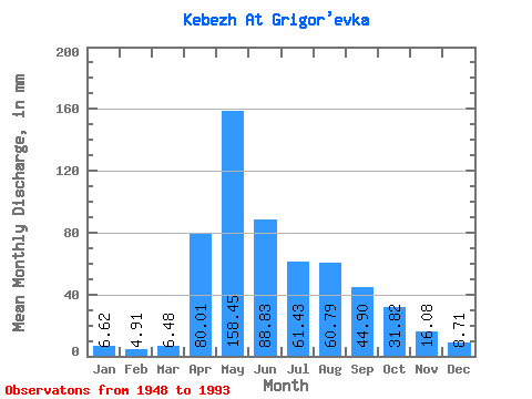
| Units: | m3/s |
| Statistic | Jan | Feb | Mar | Apr | May | Jun | Jul | Aug | Sep | Oct | Nov | Dec | Annual |
|---|---|---|---|---|---|---|---|---|---|---|---|---|---|
| Mean | 6.62 | 4.95 | 6.49 | 80.01 | 158.43 | 88.83 | 61.42 | 60.78 | 44.90 | 31.81 | 16.08 | 8.71 | 567.53 |
| Standard Deviation | 1.95 | 1.27 | 2.12 | 34.29 | 58.39 | 36.90 | 38.57 | 39.50 | 19.44 | 15.07 | 7.97 | 2.83 | 120.50 |
| Min | 3.29 | 2.05 | 2.68 | 35.51 | 80.88 | 27.48 | 16.09 | 10.20 | 17.32 | 13.82 | 8.32 | 4.82 | 375.83 |
| Max | 11.92 | 7.76 | 14.78 | 201.66 | 332.07 | 194.14 | 205.40 | 213.97 | 99.01 | 80.88 | 39.92 | 19.01 | 876.32 |
| Coefficient of Variation | 0.29 | 0.26 | 0.33 | 0.43 | 0.37 | 0.41 | 0.63 | 0.65 | 0.43 | 0.47 | 0.50 | 0.33 | 0.21 |
 Return to R-Arctic Net Home Page