|
|
|||||||||||||||||
| Point ID: 6566 | Downloads | Plots | Site Data | Code: 9199 |
|
|
|||||||||||||||||
| Download | |
|---|---|
| Site Descriptor Information | Site Time Series Data |
| Link to all available data | |
|
|
| View: | Statistics | Time Series |
| Units: | m3/s |
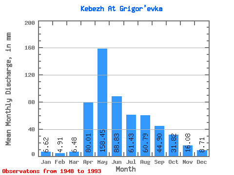
| Statistic | Jan | Feb | Mar | Apr | May | Jun | Jul | Aug | Sep | Oct | Nov | Dec | Annual |
|---|---|---|---|---|---|---|---|---|---|---|---|---|---|
| Mean | 6.62 | 4.95 | 6.49 | 80.01 | 158.43 | 88.83 | 61.42 | 60.78 | 44.90 | 31.81 | 16.08 | 8.71 | 567.53 |
| Standard Deviation | 1.95 | 1.27 | 2.12 | 34.29 | 58.39 | 36.90 | 38.57 | 39.50 | 19.44 | 15.07 | 7.97 | 2.83 | 120.50 |
| Min | 3.29 | 2.05 | 2.68 | 35.51 | 80.88 | 27.48 | 16.09 | 10.20 | 17.32 | 13.82 | 8.32 | 4.82 | 375.83 |
| Max | 11.92 | 7.76 | 14.78 | 201.66 | 332.07 | 194.14 | 205.40 | 213.97 | 99.01 | 80.88 | 39.92 | 19.01 | 876.32 |
| Coefficient of Variation | 0.29 | 0.26 | 0.33 | 0.43 | 0.37 | 0.41 | 0.63 | 0.65 | 0.43 | 0.47 | 0.50 | 0.33 | 0.21 |
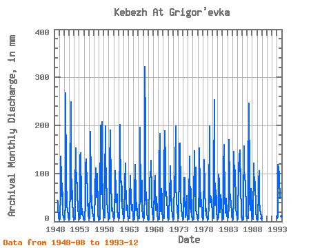
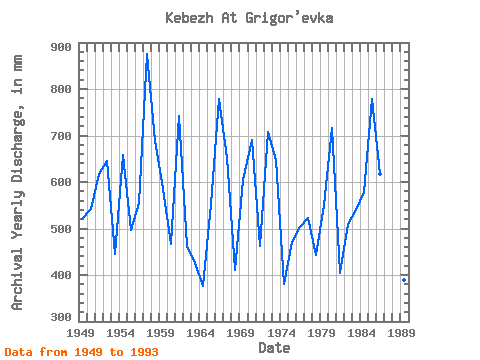
| Year | Jan | Feb | Mar | Apr | May | Jun | Jul | Aug | Sep | Oct | Nov | Dec | Annual | 1948 | 45.26 | 41.99 | 24.88 | 11.87 | 6.80 | 1949 | 5.44 | 4.39 | 4.71 | 64.02 | 139.79 | 93.83 | 53.56 | 81.95 | 41.99 | 17.19 | 9.41 | 5.70 | 519.87 | 1950 | 5.41 | 4.12 | 7.79 | 38.36 | 275.83 | 94.09 | 32.94 | 36.15 | 21.46 | 16.63 | 8.50 | 6.24 | 543.41 | 1951 | 4.90 | 4.27 | 5.36 | 77.76 | 257.36 | 58.06 | 47.94 | 91.32 | 41.47 | 17.38 | 10.26 | 5.89 | 617.34 | 1952 | 4.29 | 4.32 | 5.22 | 60.91 | 157.20 | 123.38 | 82.22 | 83.55 | 49.77 | 37.49 | 28.77 | 10.34 | 644.82 | 1953 | 7.20 | 5.12 | 6.64 | 135.30 | 147.02 | 45.36 | 16.09 | 26.48 | 26.70 | 15.93 | 8.35 | 5.44 | 445.18 | 1954 | 3.88 | 2.78 | 3.43 | 38.36 | 119.97 | 130.38 | 121.31 | 88.91 | 69.72 | 32.94 | 36.55 | 12.94 | 658.55 | 1955 | 6.78 | 6.39 | 11.36 | 69.72 | 193.89 | 80.87 | 28.66 | 31.07 | 31.10 | 19.68 | 11.09 | 8.14 | 496.70 | 1956 | 3.29 | 2.05 | 2.68 | 64.80 | 114.08 | 88.91 | 82.75 | 52.49 | 99.01 | 27.32 | 13.35 | 6.62 | 556.22 | 1957 | 4.66 | 3.27 | 4.66 | 42.25 | 206.74 | 157.85 | 59.18 | 213.97 | 57.80 | 80.88 | 35.51 | 15.48 | 876.32 | 1958 | 9.19 | 7.76 | 7.90 | 81.65 | 204.87 | 147.74 | 77.66 | 63.47 | 46.91 | 21.80 | 14.54 | 7.87 | 689.19 | 1959 | 6.11 | 4.86 | 6.45 | 117.16 | 196.83 | 67.91 | 78.47 | 38.56 | 21.77 | 28.66 | 11.82 | 9.11 | 584.75 | 1960 | 7.45 | 6.15 | 6.91 | 84.24 | 109.26 | 66.10 | 40.44 | 44.45 | 57.28 | 25.07 | 11.79 | 9.35 | 467.82 | 1961 | 7.42 | 6.59 | 7.61 | 201.66 | 143.00 | 117.94 | 43.38 | 87.30 | 64.80 | 35.88 | 17.24 | 9.19 | 742.42 | 1962 | 7.18 | 6.15 | 14.78 | 77.76 | 124.80 | 68.17 | 61.06 | 24.96 | 24.57 | 34.28 | 12.26 | 8.70 | 462.88 | 1963 | 6.16 | 5.56 | 6.00 | 40.18 | 98.55 | 85.80 | 49.54 | 24.40 | 32.14 | 36.69 | 29.29 | 12.00 | 425.30 | 1964 | 8.44 | 3.12 | 5.04 | 54.69 | 121.85 | 52.36 | 24.91 | 36.69 | 39.66 | 15.77 | 8.32 | 6.40 | 375.83 | 1965 | 6.40 | 5.54 | 6.29 | 65.58 | 202.72 | 40.69 | 48.20 | 44.72 | 85.54 | 26.59 | 14.64 | 9.86 | 554.06 | 1966 | 8.33 | 6.93 | 7.37 | 62.21 | 332.07 | 194.14 | 45.26 | 63.20 | 31.36 | 17.51 | 8.66 | 4.82 | 778.16 | 1967 | 4.12 | 3.39 | 5.65 | 85.28 | 88.11 | 96.16 | 114.08 | 131.22 | 58.84 | 40.97 | 16.23 | 10.98 | 651.98 | 1968 | 7.55 | 4.64 | 9.40 | 76.98 | 99.09 | 48.73 | 24.99 | 44.99 | 50.80 | 23.97 | 12.00 | 7.85 | 410.20 | 1969 | 5.87 | 4.78 | 5.76 | 111.97 | 188.53 | 76.98 | 21.26 | 42.58 | 68.17 | 50.61 | 19.91 | 8.76 | 603.82 | 1970 | 7.50 | 5.91 | 6.03 | 109.64 | 195.49 | 119.23 | 55.97 | 63.74 | 53.91 | 50.61 | 16.77 | 8.57 | 691.27 | 1971 | 6.80 | 4.46 | 5.04 | 59.88 | 82.48 | 42.25 | 119.71 | 57.04 | 37.33 | 25.41 | 14.98 | 9.86 | 462.35 | 1972 | 7.20 | 5.10 | 7.53 | 91.24 | 80.88 | 111.20 | 205.40 | 68.56 | 53.14 | 44.45 | 24.21 | 11.27 | 707.05 | 1973 | 9.00 | 6.32 | 7.87 | 113.79 | 168.71 | 162.26 | 68.29 | 50.35 | 24.75 | 15.83 | 11.82 | 8.57 | 646.74 | 1974 | 6.05 | 4.15 | 4.90 | 90.72 | 94.27 | 39.66 | 20.62 | 10.20 | 28.25 | 56.24 | 19.52 | 6.99 | 380.93 | 1975 | 5.78 | 4.66 | 5.60 | 41.99 | 140.33 | 115.60 | 31.87 | 19.47 | 67.65 | 23.70 | 10.16 | 4.93 | 471.40 | 1976 | 3.54 | 4.39 | 5.06 | 42.77 | 152.38 | 52.62 | 74.18 | 116.22 | 23.74 | 18.43 | 8.63 | 7.04 | 504.46 | 1977 | 4.31 | 3.51 | 5.95 | 90.98 | 158.27 | 66.87 | 32.40 | 61.06 | 30.59 | 44.19 | 17.68 | 9.32 | 522.76 | 1978 | 7.04 | 4.69 | 6.78 | 118.19 | 133.10 | 73.09 | 21.48 | 25.09 | 25.92 | 13.82 | 8.76 | 5.30 | 443.13 | 1979 | 3.75 | 4.20 | 4.82 | 37.33 | 204.87 | 66.36 | 42.31 | 40.97 | 50.28 | 40.97 | 39.92 | 19.01 | 551.56 | 1980 | 11.92 | 5.69 | 6.62 | 85.54 | 261.37 | 125.19 | 35.35 | 51.42 | 64.54 | 43.92 | 19.98 | 8.81 | 717.60 | 1981 | 8.52 | 5.22 | 8.06 | 98.50 | 85.70 | 27.48 | 20.14 | 35.08 | 54.95 | 38.56 | 14.31 | 8.81 | 404.92 | 1982 | 7.31 | 5.08 | 5.30 | 112.23 | 164.97 | 47.17 | 41.78 | 29.73 | 17.32 | 50.08 | 20.58 | 10.90 | 510.17 | 1983 | 9.27 | 7.15 | 8.20 | 35.51 | 175.94 | 80.09 | 65.61 | 52.49 | 38.62 | 36.69 | 22.42 | 11.62 | 540.31 | 1984 | 6.48 | 3.66 | 5.04 | 47.17 | 149.70 | 89.94 | 85.16 | 109.80 | 34.73 | 24.29 | 17.83 | 8.44 | 578.34 | 1985 | 7.20 | 6.05 | 5.54 | 104.46 | 146.49 | 103.68 | 147.29 | 153.99 | 70.50 | 22.23 | 9.90 | 5.84 | 779.11 | 1986 | 4.74 | 3.42 | 3.80 | 38.62 | 161.75 | 108.35 | 93.19 | 84.09 | 72.06 | 31.07 | 11.28 | 8.09 | 617.16 | 1987 | 8.17 | 5.66 | 6.67 | 89.42 | 254.41 | 92.53 | 47.13 | 24.50 | 26.44 | 70.97 | 21.15 | 11.57 | 654.84 | 1988 | 7.53 | 5.76 | 5.73 | 121.31 | 122.12 | 68.43 | 83.29 | 85.70 | 24.47 | 20.19 | 8.48 | 5.76 | 556.53 | 1989 | 5.06 | 3.90 | 7.53 | 61.95 | 84.89 | 104.98 | 42.85 | 24.96 | 18.04 | 17.17 | 11.20 | 6.86 | 389.16 | 1993 | 10.98 | 6.64 | 9.32 | 118.45 | 114.35 | 98.24 | 91.59 | 51.42 | 50.54 | 31.07 | 11.40 | 8.60 | 601.51 |
|---|
 Return to R-Arctic Net Home Page